You are here: Home > Network List > CI - Caltech Regional Seismic Network Stations List
> Station ISA Isabella, Lake Isabella, CA, USA > Earthquake Result Viewer
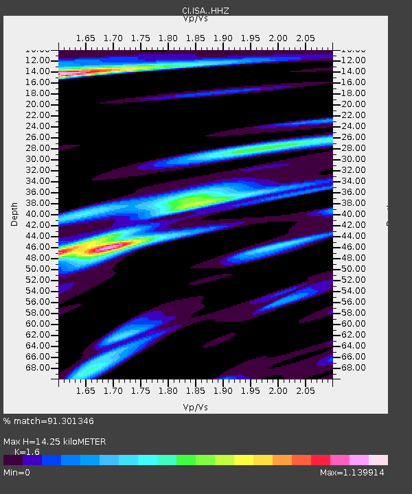
ISA Isabella, Lake Isabella, CA, USA - Earthquake Result Viewer
| Earthquake location: |
Alaska Peninsula |
| Earthquake latitude/longitude: |
54.5/-160.8 |
| Earthquake time(UTC): |
2023/07/16 (197) 06:48:21 GMT |
| Earthquake Depth: |
21 km |
| Earthquake Magnitude: |
7.3 Mi |
| Earthquake Catalog/Contributor: |
NEIC PDE/at |
|
| Network: |
CI Caltech Regional Seismic Network |
| Station: |
ISA Isabella, Lake Isabella, CA, USA |
| Lat/Lon: |
35.66 N/118.47 W |
| Elevation: |
873 m |
|
| Distance: |
34.6 deg |
| Az: |
105.335 deg |
| Baz: |
316.294 deg |
| Ray Param: |
0.077615805 |
| Estimated Moho Depth: |
14.25 km |
| Estimated Crust Vp/Vs: |
1.60 |
| Assumed Crust Vp: |
6.1 km/s |
| Estimated Crust Vs: |
3.812 km/s |
| Estimated Crust Poisson's Ratio: |
0.18 |
|
| Radial Match: |
91.301346 % |
| Radial Bump: |
350 |
| Transverse Match: |
76.63788 % |
| Transverse Bump: |
400 |
| SOD ConfigId: |
30536071 |
| Insert Time: |
2023-07-30 06:57:53.816 +0000 |
| GWidth: |
2.5 |
| Max Bumps: |
400 |
| Tol: |
0.001 |
|

Signal To Noise
| Channel | StoN | STA | LTA |
| CI:ISA: :HHZ:20230716T06:54:38.130005Z | 6.6643214 | 1.0147849E-6 | 1.522713E-7 |
| CI:ISA: :HHN:20230716T06:54:38.130005Z | 5.2039967 | 4.6328904E-7 | 8.9025626E-8 |
| CI:ISA: :HHE:20230716T06:54:38.130005Z | 4.5256877 | 2.8345784E-7 | 6.263309E-8 |
| Arrivals |
| Ps | 1.5 SECOND |
| PpPs | 5.6 SECOND |
| PsPs/PpSs | 7.1 SECOND |


