You are here: Home > Network List > CI - Caltech Regional Seismic Network Stations List
> Station NEE2 Needles Airport > Earthquake Result Viewer
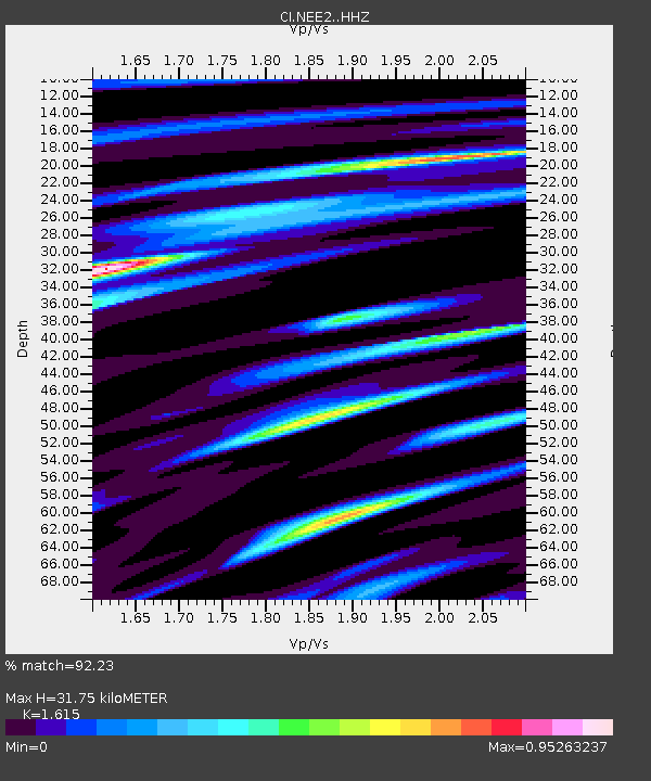
NEE2 Needles Airport - Earthquake Result Viewer
| Earthquake location: |
Alaska Peninsula |
| Earthquake latitude/longitude: |
54.5/-160.8 |
| Earthquake time(UTC): |
2023/07/16 (197) 06:48:21 GMT |
| Earthquake Depth: |
21 km |
| Earthquake Magnitude: |
7.3 Mi |
| Earthquake Catalog/Contributor: |
NEIC PDE/at |
|
| Network: |
CI Caltech Regional Seismic Network |
| Station: |
NEE2 Needles Airport |
| Lat/Lon: |
34.77 N/114.62 W |
| Elevation: |
271 m |
|
| Distance: |
37.5 deg |
| Az: |
102.509 deg |
| Baz: |
316.223 deg |
| Ray Param: |
0.07609256 |
| Estimated Moho Depth: |
31.75 km |
| Estimated Crust Vp/Vs: |
1.62 |
| Assumed Crust Vp: |
6.276 km/s |
| Estimated Crust Vs: |
3.886 km/s |
| Estimated Crust Poisson's Ratio: |
0.19 |
|
| Radial Match: |
92.23 % |
| Radial Bump: |
400 |
| Transverse Match: |
69.21148 % |
| Transverse Bump: |
400 |
| SOD ConfigId: |
30536071 |
| Insert Time: |
2023-07-30 06:58:18.068 +0000 |
| GWidth: |
2.5 |
| Max Bumps: |
400 |
| Tol: |
0.001 |
|

Signal To Noise
| Channel | StoN | STA | LTA |
| CI:NEE2: :HHZ:20230716T06:55:02.279999Z | 6.076361 | 9.461554E-7 | 1.5571086E-7 |
| CI:NEE2: :HHN:20230716T06:55:02.279999Z | 2.2557254 | 3.9778772E-7 | 1.7634581E-7 |
| CI:NEE2: :HHE:20230716T06:55:02.279999Z | 1.9697046 | 3.2648498E-7 | 1.6575326E-7 |
| Arrivals |
| Ps | 3.4 SECOND |
| PpPs | 12 SECOND |
| PsPs/PpSs | 16 SECOND |


