You are here: Home > Network List > CI - Caltech Regional Seismic Network Stations List
> Station VES Vestal, Richgrove, CA, USA > Earthquake Result Viewer
VES Vestal, Richgrove, CA, USA - Earthquake Result Viewer
| Earthquake location: |
Alaska Peninsula |
| Earthquake latitude/longitude: |
54.5/-160.8 |
| Earthquake time(UTC): |
2023/07/16 (197) 06:48:21 GMT |
| Earthquake Depth: |
21 km |
| Earthquake Magnitude: |
7.3 Mi |
| Earthquake Catalog/Contributor: |
NEIC PDE/at |
|
| Network: |
CI Caltech Regional Seismic Network |
| Station: |
VES Vestal, Richgrove, CA, USA |
| Lat/Lon: |
35.84 N/119.08 W |
| Elevation: |
154 m |
|
| Distance: |
34.2 deg |
| Az: |
105.753 deg |
| Baz: |
316.283 deg |
| Ray Param: |
0.077849455 |
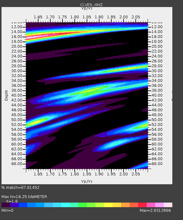
| Estimated Moho Depth: |
16.25 km |
| Estimated Crust Vp/Vs: |
1.60 |
| Assumed Crust Vp: |
6.1 km/s |
| Estimated Crust Vs: |
3.812 km/s |
| Estimated Crust Poisson's Ratio: |
0.18 |
|
| Radial Match: |
87.81452 % |
| Radial Bump: |
308 |
| Transverse Match: |
86.349464 % |
| Transverse Bump: |
378 |
| SOD ConfigId: |
30536071 |
| Insert Time: |
2023-07-30 06:59:15.387 +0000 |
| GWidth: |
2.5 |
| Max Bumps: |
400 |
| Tol: |
0.001 |
|
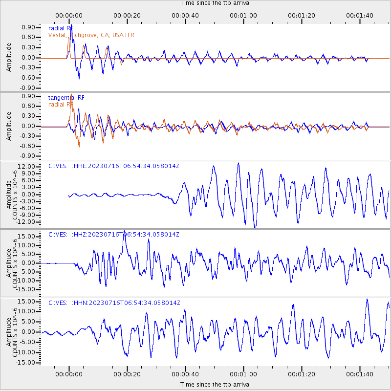
Signal To Noise
| Channel | StoN | STA | LTA |
| CI:VES: :HHZ:20230716T06:54:34.058014Z | 11.4354315 | 1.5941079E-6 | 1.3940077E-7 |
| CI:VES: :HHN:20230716T06:54:34.058014Z | 1.4138925 | 1.086313E-6 | 7.6831367E-7 |
| CI:VES: :HHE:20230716T06:54:34.058014Z | 1.8322743 | 7.343668E-7 | 4.0079522E-7 |
| Arrivals |
| Ps | 1.7 SECOND |
| PpPs | 6.4 SECOND |
| PsPs/PpSs | 8.1 SECOND |


