You are here: Home > Network List > G - GEOSCOPE Stations List
> Station INU Inuyama, Japan > Earthquake Result Viewer
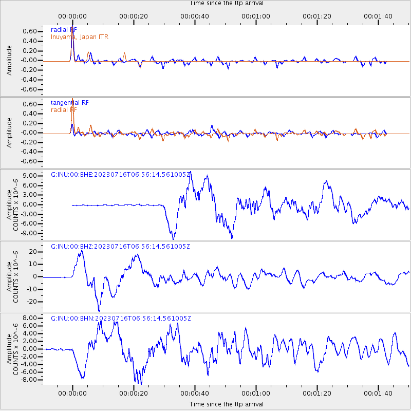
INU Inuyama, Japan - Earthquake Result Viewer

| Earthquake location: |
Alaska Peninsula |
| Earthquake latitude/longitude: |
54.5/-160.8 |
| Earthquake time(UTC): |
2023/07/16 (197) 06:48:21 GMT |
| Earthquake Depth: |
21 km |
| Earthquake Magnitude: |
7.3 Mi |
| Earthquake Catalog/Contributor: |
NEIC PDE/at |
|
| Network: |
G GEOSCOPE |
| Station: |
INU Inuyama, Japan |
| Lat/Lon: |
35.35 N/137.03 E |
| Elevation: |
132 m |
|
| Distance: |
46.3 deg |
| Az: |
272.072 deg |
| Baz: |
45.499 deg |
| Ray Param: |
0.07069141 |
| Estimated Moho Depth: |
15.0 km |
| Estimated Crust Vp/Vs: |
1.71 |
| Assumed Crust Vp: |
6.461 km/s |
| Estimated Crust Vs: |
3.773 km/s |
| Estimated Crust Poisson's Ratio: |
0.24 |
|
| Radial Match: |
94.118675 % |
| Radial Bump: |
297 |
| Transverse Match: |
77.02397 % |
| Transverse Bump: |
400 |
| SOD ConfigId: |
30536071 |
| Insert Time: |
2023-07-30 07:04:13.186 +0000 |
| GWidth: |
2.5 |
| Max Bumps: |
400 |
| Tol: |
0.001 |
|
Signal To Noise
| Channel | StoN | STA | LTA |
| G:INU:00:BHZ:20230716T06:56:14.561005Z | 88.6038 | 1.2304459E-5 | 1.3887056E-7 |
| G:INU:00:BHN:20230716T06:56:14.561005Z | 30.968838 | 4.477937E-6 | 1.4459494E-7 |
| G:INU:00:BHE:20230716T06:56:14.561005Z | 60.446415 | 6.282478E-6 | 1.0393467E-7 |
| Arrivals |
| Ps | 1.8 SECOND |
| PpPs | 5.9 SECOND |
| PsPs/PpSs | 7.7 SECOND |


