You are here: Home > Network List > G - GEOSCOPE Stations List
> Station IVI Ivittuut, Greenland > Earthquake Result Viewer
IVI Ivittuut, Greenland - Earthquake Result Viewer
| Earthquake location: |
Alaska Peninsula |
| Earthquake latitude/longitude: |
54.5/-160.8 |
| Earthquake time(UTC): |
2023/07/16 (197) 06:48:21 GMT |
| Earthquake Depth: |
21 km |
| Earthquake Magnitude: |
7.3 Mi |
| Earthquake Catalog/Contributor: |
NEIC PDE/at |
|
| Network: |
G GEOSCOPE |
| Station: |
IVI Ivittuut, Greenland |
| Lat/Lon: |
61.21 N/48.17 W |
| Elevation: |
15 m |
|
| Distance: |
53.0 deg |
| Az: |
34.032 deg |
| Baz: |
317.592 deg |
| Ray Param: |
0.06638402 |
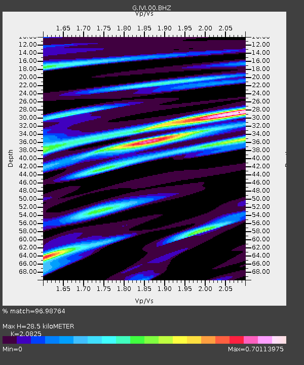
| Estimated Moho Depth: |
28.5 km |
| Estimated Crust Vp/Vs: |
2.08 |
| Assumed Crust Vp: |
6.472 km/s |
| Estimated Crust Vs: |
3.108 km/s |
| Estimated Crust Poisson's Ratio: |
0.35 |
|
| Radial Match: |
96.98764 % |
| Radial Bump: |
400 |
| Transverse Match: |
91.512924 % |
| Transverse Bump: |
400 |
| SOD ConfigId: |
30536071 |
| Insert Time: |
2023-07-30 07:04:20.553 +0000 |
| GWidth: |
2.5 |
| Max Bumps: |
400 |
| Tol: |
0.001 |
|
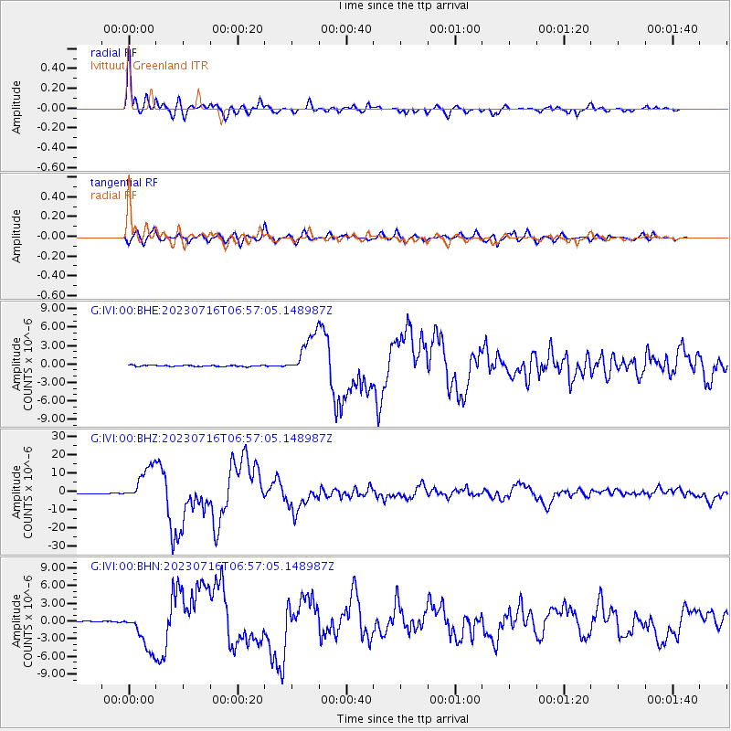
Signal To Noise
| Channel | StoN | STA | LTA |
| G:IVI:00:BHZ:20230716T06:57:05.148987Z | 99.32046 | 1.0137237E-5 | 1.02065954E-7 |
| G:IVI:00:BHN:20230716T06:57:05.148987Z | 41.908134 | 3.4278924E-6 | 8.179539E-8 |
| G:IVI:00:BHE:20230716T06:57:05.148987Z | 33.358772 | 3.420959E-6 | 1.0255051E-7 |
| Arrivals |
| Ps | 5.0 SECOND |
| PpPs | 13 SECOND |
| PsPs/PpSs | 18 SECOND |


