You are here: Home > Network List > GB - Great Britain Seismograph Network Stations List
> Station DYA YADSWORTHY, ENGLAND > Earthquake Result Viewer
DYA YADSWORTHY, ENGLAND - Earthquake Result Viewer
| Earthquake location: |
Alaska Peninsula |
| Earthquake latitude/longitude: |
54.5/-160.8 |
| Earthquake time(UTC): |
2023/07/16 (197) 06:48:21 GMT |
| Earthquake Depth: |
21 km |
| Earthquake Magnitude: |
7.3 Mi |
| Earthquake Catalog/Contributor: |
NEIC PDE/at |
|
| Network: |
GB Great Britain Seismograph Network |
| Station: |
DYA YADSWORTHY, ENGLAND |
| Lat/Lon: |
50.44 N/3.93 W |
| Elevation: |
292 m |
|
| Distance: |
73.7 deg |
| Az: |
15.179 deg |
| Baz: |
346.18 deg |
| Ray Param: |
0.052833393 |
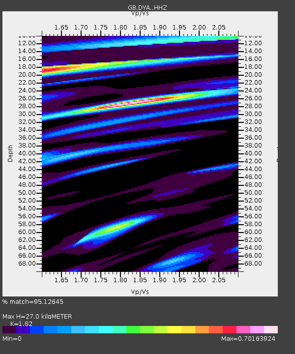
| Estimated Moho Depth: |
27.0 km |
| Estimated Crust Vp/Vs: |
1.82 |
| Assumed Crust Vp: |
6.182 km/s |
| Estimated Crust Vs: |
3.397 km/s |
| Estimated Crust Poisson's Ratio: |
0.28 |
|
| Radial Match: |
95.12645 % |
| Radial Bump: |
400 |
| Transverse Match: |
85.39003 % |
| Transverse Bump: |
400 |
| SOD ConfigId: |
30536071 |
| Insert Time: |
2023-07-30 07:04:33.132 +0000 |
| GWidth: |
2.5 |
| Max Bumps: |
400 |
| Tol: |
0.001 |
|

Signal To Noise
| Channel | StoN | STA | LTA |
| GB:DYA: :HHZ:20230716T06:59:21.72998Z | 22.230131 | 9.681147E-6 | 4.3549662E-7 |
| GB:DYA: :HHN:20230716T06:59:21.72998Z | 7.053256 | 4.1279955E-6 | 5.85261E-7 |
| GB:DYA: :HHE:20230716T06:59:21.72998Z | 2.8297765 | 8.327146E-7 | 2.942687E-7 |
| Arrivals |
| Ps | 3.7 SECOND |
| PpPs | 12 SECOND |
| PsPs/PpSs | 16 SECOND |


