You are here: Home > Network List > GB - Great Britain Seismograph Network Stations List
> Station MCH1 MICHAELCHURCH, WALES > Earthquake Result Viewer
MCH1 MICHAELCHURCH, WALES - Earthquake Result Viewer
| Earthquake location: |
Alaska Peninsula |
| Earthquake latitude/longitude: |
54.5/-160.8 |
| Earthquake time(UTC): |
2023/07/16 (197) 06:48:21 GMT |
| Earthquake Depth: |
21 km |
| Earthquake Magnitude: |
7.3 Mi |
| Earthquake Catalog/Contributor: |
NEIC PDE/at |
|
| Network: |
GB Great Britain Seismograph Network |
| Station: |
MCH1 MICHAELCHURCH, WALES |
| Lat/Lon: |
52.00 N/3.00 W |
| Elevation: |
219 m |
|
| Distance: |
72.3 deg |
| Az: |
14.198 deg |
| Baz: |
346.618 deg |
| Ray Param: |
0.053746488 |
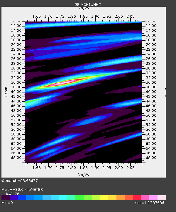
| Estimated Moho Depth: |
36.0 km |
| Estimated Crust Vp/Vs: |
1.76 |
| Assumed Crust Vp: |
6.182 km/s |
| Estimated Crust Vs: |
3.513 km/s |
| Estimated Crust Poisson's Ratio: |
0.26 |
|
| Radial Match: |
93.66677 % |
| Radial Bump: |
348 |
| Transverse Match: |
80.247215 % |
| Transverse Bump: |
400 |
| SOD ConfigId: |
30536071 |
| Insert Time: |
2023-07-30 07:05:20.207 +0000 |
| GWidth: |
2.5 |
| Max Bumps: |
400 |
| Tol: |
0.001 |
|

Signal To Noise
| Channel | StoN | STA | LTA |
| GB:MCH1: :HHZ:20230716T06:59:13.570007Z | 16.686855 | 1.8168167E-6 | 1.0887712E-7 |
| GB:MCH1: :HHN:20230716T06:59:13.570007Z | 6.3390493 | 7.2195087E-7 | 1.1388945E-7 |
| GB:MCH1: :HHE:20230716T06:59:13.570007Z | 2.59676 | 2.197158E-7 | 8.4611514E-8 |
| Arrivals |
| Ps | 4.6 SECOND |
| PpPs | 16 SECOND |
| PsPs/PpSs | 20 SECOND |


