You are here: Home > Network List > GS - US Geological Survey Networks Stations List
> Station ASA5 ASA5 > Earthquake Result Viewer
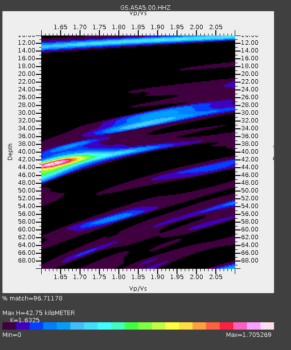
ASA5 ASA5 - Earthquake Result Viewer
| Earthquake location: |
Alaska Peninsula |
| Earthquake latitude/longitude: |
54.5/-160.8 |
| Earthquake time(UTC): |
2023/07/16 (197) 06:48:21 GMT |
| Earthquake Depth: |
21 km |
| Earthquake Magnitude: |
7.3 Mi |
| Earthquake Catalog/Contributor: |
NEIC PDE/at |
|
| Network: |
GS US Geological Survey Networks |
| Station: |
ASA5 ASA5 |
| Lat/Lon: |
34.94 N/106.46 W |
| Elevation: |
1835 m |
|
| Distance: |
42.1 deg |
| Az: |
94.825 deg |
| Baz: |
314.955 deg |
| Ray Param: |
0.07337022 |
| Estimated Moho Depth: |
42.75 km |
| Estimated Crust Vp/Vs: |
1.63 |
| Assumed Crust Vp: |
6.502 km/s |
| Estimated Crust Vs: |
3.983 km/s |
| Estimated Crust Poisson's Ratio: |
0.20 |
|
| Radial Match: |
96.71178 % |
| Radial Bump: |
272 |
| Transverse Match: |
81.57681 % |
| Transverse Bump: |
400 |
| SOD ConfigId: |
30536071 |
| Insert Time: |
2023-07-30 07:07:22.290 +0000 |
| GWidth: |
2.5 |
| Max Bumps: |
400 |
| Tol: |
0.001 |
|

Signal To Noise
| Channel | StoN | STA | LTA |
| GS:ASA5:00:HHZ:20230716T06:55:40.299011Z | 3.3328905 | 2.8670806E-7 | 8.6023846E-8 |
| GS:ASA5:00:HH1:20230716T06:55:40.299011Z | 2.556011 | 1.2254216E-7 | 4.7942738E-8 |
| GS:ASA5:00:HH2:20230716T06:55:40.299011Z | 2.665586 | 1.4132335E-7 | 5.3017743E-8 |
| Arrivals |
| Ps | 4.5 SECOND |
| PpPs | 16 SECOND |
| PsPs/PpSs | 21 SECOND |


