You are here: Home > Network List > TA - USArray Transportable Network (new EarthScope stations) Stations List
> Station S29A Ulysses, KS, USA > Earthquake Result Viewer
S29A Ulysses, KS, USA - Earthquake Result Viewer
| Earthquake location: |
Costa Rica |
| Earthquake latitude/longitude: |
9.3/-84.2 |
| Earthquake time(UTC): |
2010/06/01 (152) 03:26:15 GMT |
| Earthquake Depth: |
18 km |
| Earthquake Magnitude: |
5.7 MB, 5.6 MS, 6.0 MW, 5.9 MW |
| Earthquake Catalog/Contributor: |
WHDF/NEIC |
|
| Network: |
TA USArray Transportable Network (new EarthScope stations) |
| Station: |
S29A Ulysses, KS, USA |
| Lat/Lon: |
37.62 N/101.12 W |
| Elevation: |
931 m |
|
| Distance: |
32.0 deg |
| Az: |
334.186 deg |
| Baz: |
147.233 deg |
| Ray Param: |
0.07880643 |
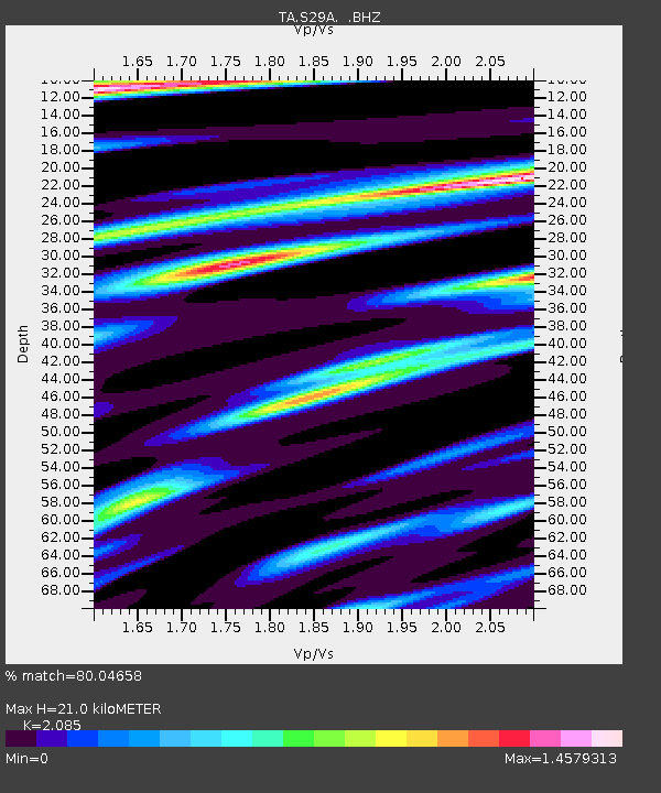
| Estimated Moho Depth: |
21.0 km |
| Estimated Crust Vp/Vs: |
2.09 |
| Assumed Crust Vp: |
6.483 km/s |
| Estimated Crust Vs: |
3.109 km/s |
| Estimated Crust Poisson's Ratio: |
0.35 |
|
| Radial Match: |
80.04658 % |
| Radial Bump: |
330 |
| Transverse Match: |
61.637238 % |
| Transverse Bump: |
400 |
| SOD ConfigId: |
317696 |
| Insert Time: |
2010-09-19 07:06:55.876 +0000 |
| GWidth: |
2.5 |
| Max Bumps: |
400 |
| Tol: |
0.001 |
|
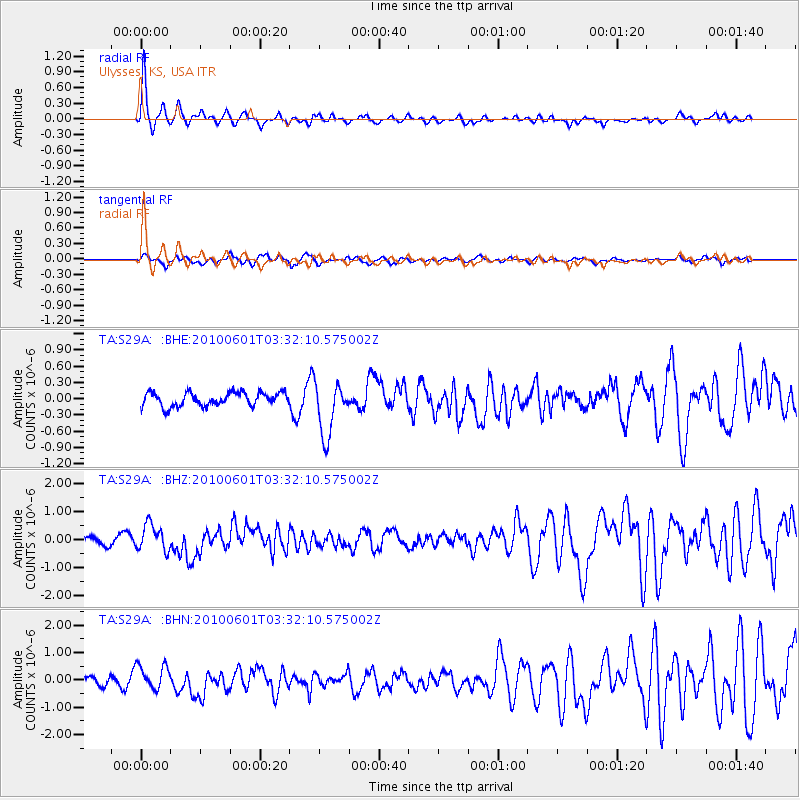
Signal To Noise
| Channel | StoN | STA | LTA |
| TA:S29A: :BHZ:20100601T03:32:10.575002Z | 2.748136 | 4.7058438E-7 | 1.7123766E-7 |
| TA:S29A: :BHN:20100601T03:32:10.575002Z | 2.1447582 | 4.5122877E-7 | 2.1038677E-7 |
| TA:S29A: :BHE:20100601T03:32:10.575002Z | 3.9215424 | 4.945368E-7 | 1.2610772E-7 |
| Arrivals |
| Ps | 3.8 SECOND |
| PpPs | 9.3 SECOND |
| PsPs/PpSs | 13 SECOND |


