You are here: Home > Network List > IE - INL Seismic Monitoring Program Stations List
> Station BCYI Bear Canyon, Idaho, USA > Earthquake Result Viewer
BCYI Bear Canyon, Idaho, USA - Earthquake Result Viewer
| Earthquake location: |
Alaska Peninsula |
| Earthquake latitude/longitude: |
54.5/-160.8 |
| Earthquake time(UTC): |
2023/07/16 (197) 06:48:21 GMT |
| Earthquake Depth: |
21 km |
| Earthquake Magnitude: |
7.3 Mi |
| Earthquake Catalog/Contributor: |
NEIC PDE/at |
|
| Network: |
IE INL Seismic Monitoring Program |
| Station: |
BCYI Bear Canyon, Idaho, USA |
| Lat/Lon: |
44.31 N/113.41 W |
| Elevation: |
2194 m |
|
| Distance: |
31.9 deg |
| Az: |
88.761 deg |
| Baz: |
305.659 deg |
| Ray Param: |
0.078872286 |
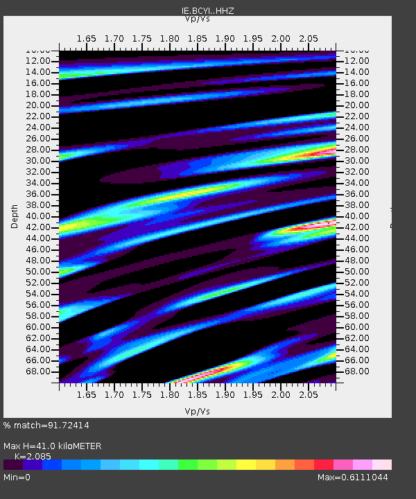
| Estimated Moho Depth: |
41.0 km |
| Estimated Crust Vp/Vs: |
2.09 |
| Assumed Crust Vp: |
6.577 km/s |
| Estimated Crust Vs: |
3.154 km/s |
| Estimated Crust Poisson's Ratio: |
0.35 |
|
| Radial Match: |
91.72414 % |
| Radial Bump: |
386 |
| Transverse Match: |
85.28809 % |
| Transverse Bump: |
400 |
| SOD ConfigId: |
30536071 |
| Insert Time: |
2023-07-30 07:09:24.080 +0000 |
| GWidth: |
2.5 |
| Max Bumps: |
400 |
| Tol: |
0.001 |
|

Signal To Noise
| Channel | StoN | STA | LTA |
| IE:BCYI: :HHZ:20230716T06:54:14.26001Z | 5.2331424 | 4.0136192E-7 | 7.669616E-8 |
| IE:BCYI: :HHN:20230716T06:54:14.26001Z | 2.8269904 | 1.7213972E-7 | 6.089151E-8 |
| IE:BCYI: :HHE:20230716T06:54:14.26001Z | 3.569327 | 3.170181E-7 | 8.881734E-8 |
| Arrivals |
| Ps | 7.3 SECOND |
| PpPs | 18 SECOND |
| PsPs/PpSs | 25 SECOND |


