You are here: Home > Network List > TA - USArray Transportable Network (new EarthScope stations) Stations List
> Station Q30A Quinter, KS, USA > Earthquake Result Viewer
Q30A Quinter, KS, USA - Earthquake Result Viewer

| Earthquake location: |
Costa Rica |
| Earthquake latitude/longitude: |
9.3/-84.2 |
| Earthquake time(UTC): |
2010/06/01 (152) 03:26:15 GMT |
| Earthquake Depth: |
18 km |
| Earthquake Magnitude: |
5.7 MB, 5.6 MS, 6.0 MW, 5.9 MW |
| Earthquake Catalog/Contributor: |
WHDF/NEIC |
|
| Network: |
TA USArray Transportable Network (new EarthScope stations) |
| Station: |
Q30A Quinter, KS, USA |
| Lat/Lon: |
38.98 N/100.22 W |
| Elevation: |
797 m |
|
| Distance: |
32.8 deg |
| Az: |
336.628 deg |
| Baz: |
149.848 deg |
| Ray Param: |
0.078471564 |
| Estimated Moho Depth: |
25.25 km |
| Estimated Crust Vp/Vs: |
1.76 |
| Assumed Crust Vp: |
6.483 km/s |
| Estimated Crust Vs: |
3.689 km/s |
| Estimated Crust Poisson's Ratio: |
0.26 |
|
| Radial Match: |
84.598724 % |
| Radial Bump: |
299 |
| Transverse Match: |
66.15008 % |
| Transverse Bump: |
400 |
| SOD ConfigId: |
317696 |
| Insert Time: |
2010-09-19 07:07:45.065 +0000 |
| GWidth: |
2.5 |
| Max Bumps: |
400 |
| Tol: |
0.001 |
|
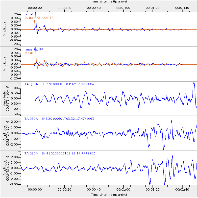
Signal To Noise
| Channel | StoN | STA | LTA |
| TA:Q30A: :BHZ:20100601T03:32:17.474996Z | 2.6214209 | 3.8736957E-7 | 1.4777083E-7 |
| TA:Q30A: :BHN:20100601T03:32:17.474996Z | 1.1960577 | 2.3826185E-7 | 1.9920599E-7 |
| TA:Q30A: :BHE:20100601T03:32:17.474996Z | 2.2501023 | 5.082706E-7 | 2.2588779E-7 |
| Arrivals |
| Ps | 3.2 SECOND |
| PpPs | 9.9 SECOND |
| PsPs/PpSs | 13 SECOND |


