You are here: Home > Network List > KO - Kandilli Observatory Digital Broadband Seismic Network Stations List
> Station DKL Dikili, Izmir, Turkey > Earthquake Result Viewer
DKL Dikili, Izmir, Turkey - Earthquake Result Viewer
| Earthquake location: |
Alaska Peninsula |
| Earthquake latitude/longitude: |
54.5/-160.8 |
| Earthquake time(UTC): |
2023/07/16 (197) 06:48:21 GMT |
| Earthquake Depth: |
21 km |
| Earthquake Magnitude: |
7.3 Mi |
| Earthquake Catalog/Contributor: |
NEIC PDE/at |
|
| Network: |
KO Kandilli Observatory Digital Broadband Seismic Network |
| Station: |
DKL Dikili, Izmir, Turkey |
| Lat/Lon: |
39.07 N/26.91 E |
| Elevation: |
35 m |
|
| Distance: |
86.6 deg |
| Az: |
354.001 deg |
| Baz: |
4.492 deg |
| Ray Param: |
0.043936446 |
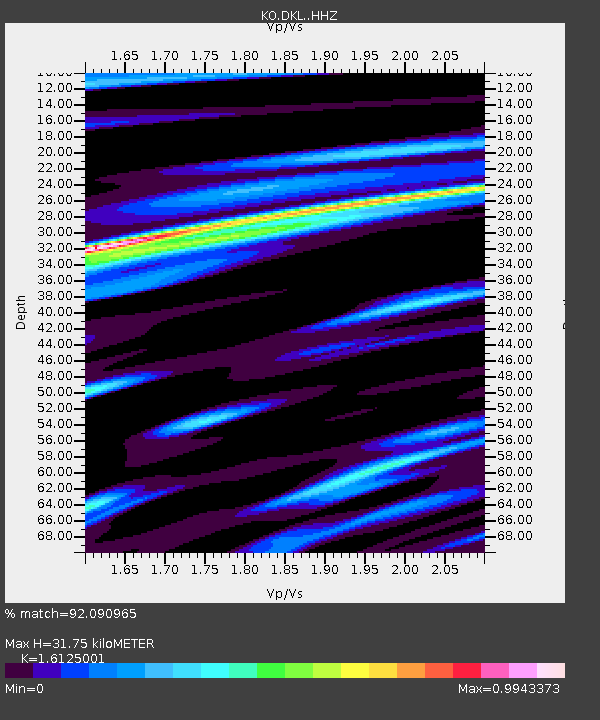
| Estimated Moho Depth: |
31.75 km |
| Estimated Crust Vp/Vs: |
1.61 |
| Assumed Crust Vp: |
6.155 km/s |
| Estimated Crust Vs: |
3.817 km/s |
| Estimated Crust Poisson's Ratio: |
0.19 |
|
| Radial Match: |
92.090965 % |
| Radial Bump: |
400 |
| Transverse Match: |
80.38233 % |
| Transverse Bump: |
400 |
| SOD ConfigId: |
30536071 |
| Insert Time: |
2023-07-30 07:12:24.649 +0000 |
| GWidth: |
2.5 |
| Max Bumps: |
400 |
| Tol: |
0.001 |
|

Signal To Noise
| Channel | StoN | STA | LTA |
| KO:DKL: :HHZ:20230716T07:00:31.090027Z | 67.62902 | 9.247324E-6 | 1.3673603E-7 |
| KO:DKL: :HHN:20230716T07:00:31.090027Z | 11.620996 | 3.423419E-6 | 2.945891E-7 |
| KO:DKL: :HHE:20230716T07:00:31.090027Z | 2.4197764 | 3.5372685E-7 | 1.4618163E-7 |
| Arrivals |
| Ps | 3.2 SECOND |
| PpPs | 13 SECOND |
| PsPs/PpSs | 16 SECOND |


