You are here: Home > Network List > N4 - Central and EAstern US Network Stations List
> Station L42A Oliver, Polo, IL, USA > Earthquake Result Viewer
L42A Oliver, Polo, IL, USA - Earthquake Result Viewer
| Earthquake location: |
Alaska Peninsula |
| Earthquake latitude/longitude: |
54.5/-160.8 |
| Earthquake time(UTC): |
2023/07/16 (197) 06:48:21 GMT |
| Earthquake Depth: |
21 km |
| Earthquake Magnitude: |
7.3 Mi |
| Earthquake Catalog/Contributor: |
NEIC PDE/at |
|
| Network: |
N4 Central and EAstern US Network |
| Station: |
L42A Oliver, Polo, IL, USA |
| Lat/Lon: |
42.00 N/89.67 W |
| Elevation: |
257 m |
|
| Distance: |
47.0 deg |
| Az: |
74.681 deg |
| Baz: |
310.977 deg |
| Ray Param: |
0.07026517 |
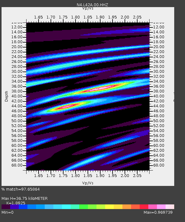
| Estimated Moho Depth: |
36.75 km |
| Estimated Crust Vp/Vs: |
1.89 |
| Assumed Crust Vp: |
6.571 km/s |
| Estimated Crust Vs: |
3.472 km/s |
| Estimated Crust Poisson's Ratio: |
0.31 |
|
| Radial Match: |
97.65864 % |
| Radial Bump: |
379 |
| Transverse Match: |
79.62706 % |
| Transverse Bump: |
400 |
| SOD ConfigId: |
30536071 |
| Insert Time: |
2023-07-30 07:17:29.600 +0000 |
| GWidth: |
2.5 |
| Max Bumps: |
400 |
| Tol: |
0.001 |
|

Signal To Noise
| Channel | StoN | STA | LTA |
| N4:L42A:00:HHZ:20230716T06:56:19.669006Z | 43.627136 | 3.1444965E-6 | 7.207662E-8 |
| N4:L42A:00:HH1:20230716T06:56:19.669006Z | 19.188202 | 1.2184036E-6 | 6.349754E-8 |
| N4:L42A:00:HH2:20230716T06:56:19.669006Z | 28.972157 | 1.3713535E-6 | 4.73335E-8 |
| Arrivals |
| Ps | 5.3 SECOND |
| PpPs | 15 SECOND |
| PsPs/PpSs | 21 SECOND |


