You are here: Home > Network List > TA - USArray Transportable Network (new EarthScope stations) Stations List
> Station I28A Midland, SD, USA > Earthquake Result Viewer
I28A Midland, SD, USA - Earthquake Result Viewer
| Earthquake location: |
Costa Rica |
| Earthquake latitude/longitude: |
9.3/-84.2 |
| Earthquake time(UTC): |
2010/06/01 (152) 03:26:15 GMT |
| Earthquake Depth: |
18 km |
| Earthquake Magnitude: |
5.7 MB, 5.6 MS, 6.0 MW, 5.9 MW |
| Earthquake Catalog/Contributor: |
WHDF/NEIC |
|
| Network: |
TA USArray Transportable Network (new EarthScope stations) |
| Station: |
I28A Midland, SD, USA |
| Lat/Lon: |
44.00 N/101.17 W |
| Elevation: |
655 m |
|
| Distance: |
37.6 deg |
| Az: |
339.792 deg |
| Baz: |
151.809 deg |
| Ray Param: |
0.07605261 |
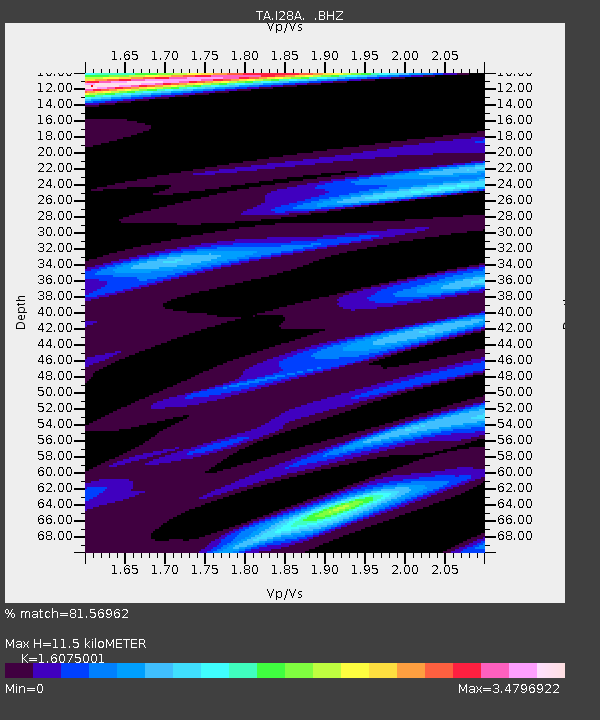
| Estimated Moho Depth: |
11.5 km |
| Estimated Crust Vp/Vs: |
1.61 |
| Assumed Crust Vp: |
6.483 km/s |
| Estimated Crust Vs: |
4.033 km/s |
| Estimated Crust Poisson's Ratio: |
0.18 |
|
| Radial Match: |
81.56962 % |
| Radial Bump: |
400 |
| Transverse Match: |
77.99117 % |
| Transverse Bump: |
400 |
| SOD ConfigId: |
317696 |
| Insert Time: |
2010-09-19 07:09:32.572 +0000 |
| GWidth: |
2.5 |
| Max Bumps: |
400 |
| Tol: |
0.001 |
|
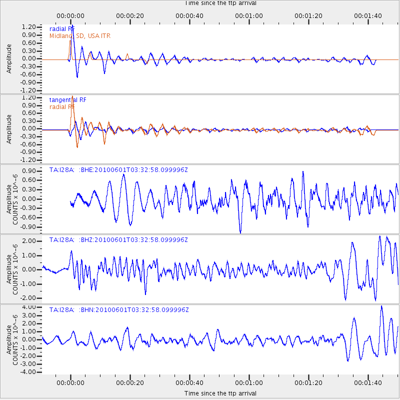
Signal To Noise
| Channel | StoN | STA | LTA |
| TA:I28A: :BHZ:20100601T03:32:58.099996Z | 4.018037 | 7.044815E-7 | 1.7532979E-7 |
| TA:I28A: :BHN:20100601T03:32:58.099996Z | 1.5891173 | 5.2106117E-7 | 3.2789347E-7 |
| TA:I28A: :BHE:20100601T03:32:58.099996Z | 0.69311124 | 2.5447017E-7 | 3.671419E-7 |
| Arrivals |
| Ps | 1.2 SECOND |
| PpPs | 4.3 SECOND |
| PsPs/PpSs | 5.4 SECOND |


