You are here: Home > Network List > N4 - Central and EAstern US Network Stations List
> Station O20A White River City, CO, USA > Earthquake Result Viewer
O20A White River City, CO, USA - Earthquake Result Viewer
| Earthquake location: |
Alaska Peninsula |
| Earthquake latitude/longitude: |
54.5/-160.8 |
| Earthquake time(UTC): |
2023/07/16 (197) 06:48:21 GMT |
| Earthquake Depth: |
21 km |
| Earthquake Magnitude: |
7.3 Mi |
| Earthquake Catalog/Contributor: |
NEIC PDE/at |
|
| Network: |
N4 Central and EAstern US Network |
| Station: |
O20A White River City, CO, USA |
| Lat/Lon: |
40.13 N/108.24 W |
| Elevation: |
1915 m |
|
| Distance: |
37.5 deg |
| Az: |
90.375 deg |
| Baz: |
310.449 deg |
| Ray Param: |
0.07608057 |
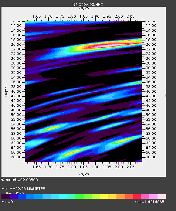
| Estimated Moho Depth: |
20.25 km |
| Estimated Crust Vp/Vs: |
1.96 |
| Assumed Crust Vp: |
6.207 km/s |
| Estimated Crust Vs: |
3.171 km/s |
| Estimated Crust Poisson's Ratio: |
0.32 |
|
| Radial Match: |
92.93593 % |
| Radial Bump: |
400 |
| Transverse Match: |
84.36694 % |
| Transverse Bump: |
400 |
| SOD ConfigId: |
30536071 |
| Insert Time: |
2023-07-30 07:17:59.251 +0000 |
| GWidth: |
2.5 |
| Max Bumps: |
400 |
| Tol: |
0.001 |
|

Signal To Noise
| Channel | StoN | STA | LTA |
| N4:O20A:00:HHZ:20230716T06:55:02.447998Z | 5.5677257 | 6.421464E-7 | 1.153337E-7 |
| N4:O20A:00:HH1:20230716T06:55:02.447998Z | 1.5818352 | 1.5510645E-7 | 9.8054755E-8 |
| N4:O20A:00:HH2:20230716T06:55:02.447998Z | 3.0232034 | 3.0550245E-7 | 1.01052564E-7 |
| Arrivals |
| Ps | 3.3 SECOND |
| PpPs | 9.1 SECOND |
| PsPs/PpSs | 12 SECOND |


