You are here: Home > Network List > N4 - Central and EAstern US Network Stations List
> Station Q51A Peebles, OH, USA > Earthquake Result Viewer
Q51A Peebles, OH, USA - Earthquake Result Viewer
| Earthquake location: |
Alaska Peninsula |
| Earthquake latitude/longitude: |
54.5/-160.8 |
| Earthquake time(UTC): |
2023/07/16 (197) 06:48:21 GMT |
| Earthquake Depth: |
21 km |
| Earthquake Magnitude: |
7.3 Mi |
| Earthquake Catalog/Contributor: |
NEIC PDE/at |
|
| Network: |
N4 Central and EAstern US Network |
| Station: |
Q51A Peebles, OH, USA |
| Lat/Lon: |
39.03 N/83.35 W |
| Elevation: |
362 m |
|
| Distance: |
52.6 deg |
| Az: |
73.278 deg |
| Baz: |
314.164 deg |
| Ray Param: |
0.06665897 |
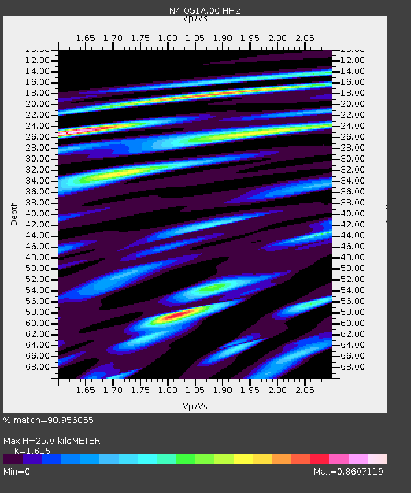
| Estimated Moho Depth: |
25.0 km |
| Estimated Crust Vp/Vs: |
1.62 |
| Assumed Crust Vp: |
6.232 km/s |
| Estimated Crust Vs: |
3.859 km/s |
| Estimated Crust Poisson's Ratio: |
0.19 |
|
| Radial Match: |
98.956055 % |
| Radial Bump: |
277 |
| Transverse Match: |
92.60962 % |
| Transverse Bump: |
400 |
| SOD ConfigId: |
30536071 |
| Insert Time: |
2023-07-30 07:18:21.676 +0000 |
| GWidth: |
2.5 |
| Max Bumps: |
400 |
| Tol: |
0.001 |
|

Signal To Noise
| Channel | StoN | STA | LTA |
| N4:Q51A:00:HHZ:20230716T06:57:01.898987Z | 64.11378 | 3.7389082E-6 | 5.831677E-8 |
| N4:Q51A:00:HH1:20230716T06:57:01.898987Z | 28.365692 | 1.5418975E-6 | 5.435783E-8 |
| N4:Q51A:00:HH2:20230716T06:57:01.898987Z | 38.29331 | 1.479751E-6 | 3.8642547E-8 |
| Arrivals |
| Ps | 2.6 SECOND |
| PpPs | 9.9 SECOND |
| PsPs/PpSs | 13 SECOND |


