You are here: Home > Network List > NE - New England Seismic Network Stations List
> Station WES Weston Observatory, Weston, MA, USA > Earthquake Result Viewer
WES Weston Observatory, Weston, MA, USA - Earthquake Result Viewer
| Earthquake location: |
Alaska Peninsula |
| Earthquake latitude/longitude: |
54.5/-160.8 |
| Earthquake time(UTC): |
2023/07/16 (197) 06:48:21 GMT |
| Earthquake Depth: |
21 km |
| Earthquake Magnitude: |
7.3 Mi |
| Earthquake Catalog/Contributor: |
NEIC PDE/at |
|
| Network: |
NE New England Seismic Network |
| Station: |
WES Weston Observatory, Weston, MA, USA |
| Lat/Lon: |
42.38 N/71.32 W |
| Elevation: |
60 m |
|
| Distance: |
56.7 deg |
| Az: |
62.46 deg |
| Baz: |
315.714 deg |
| Ray Param: |
0.06396546 |
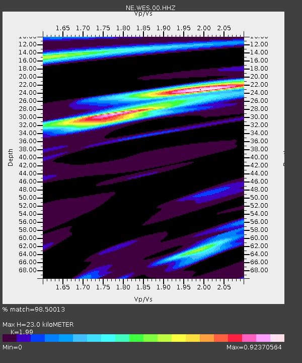
| Estimated Moho Depth: |
23.0 km |
| Estimated Crust Vp/Vs: |
1.99 |
| Assumed Crust Vp: |
6.419 km/s |
| Estimated Crust Vs: |
3.226 km/s |
| Estimated Crust Poisson's Ratio: |
0.33 |
|
| Radial Match: |
98.50013 % |
| Radial Bump: |
311 |
| Transverse Match: |
92.69302 % |
| Transverse Bump: |
400 |
| SOD ConfigId: |
30536071 |
| Insert Time: |
2023-07-30 07:20:39.234 +0000 |
| GWidth: |
2.5 |
| Max Bumps: |
400 |
| Tol: |
0.001 |
|

Signal To Noise
| Channel | StoN | STA | LTA |
| NE:WES:00:HHZ:20230716T06:57:31.739014Z | 21.964611 | 4.8872353E-6 | 2.2250498E-7 |
| NE:WES:00:HH1:20230716T06:57:31.739014Z | 14.873885 | 1.7405952E-6 | 1.17023575E-7 |
| NE:WES:00:HH2:20230716T06:57:31.739014Z | 14.409526 | 1.6661619E-6 | 1.156292E-7 |
| Arrivals |
| Ps | 3.7 SECOND |
| PpPs | 10 SECOND |
| PsPs/PpSs | 14 SECOND |


