You are here: Home > Network List > NM - Cooperative New Madrid Seismic Network Stations List
> Station PARM Stahl Farm,MO > Earthquake Result Viewer
PARM Stahl Farm,MO - Earthquake Result Viewer
| Earthquake location: |
Alaska Peninsula |
| Earthquake latitude/longitude: |
54.5/-160.8 |
| Earthquake time(UTC): |
2023/07/16 (197) 06:48:21 GMT |
| Earthquake Depth: |
21 km |
| Earthquake Magnitude: |
7.3 Mi |
| Earthquake Catalog/Contributor: |
NEIC PDE/at |
|
| Network: |
NM Cooperative New Madrid Seismic Network |
| Station: |
PARM Stahl Farm,MO |
| Lat/Lon: |
36.66 N/89.75 W |
| Elevation: |
85 m |
|
| Distance: |
50.6 deg |
| Az: |
79.952 deg |
| Baz: |
314.4 deg |
| Ray Param: |
0.06794633 |
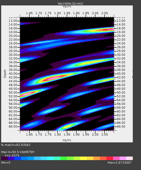
| Estimated Moho Depth: |
50.5 km |
| Estimated Crust Vp/Vs: |
1.64 |
| Assumed Crust Vp: |
6.444 km/s |
| Estimated Crust Vs: |
3.935 km/s |
| Estimated Crust Poisson's Ratio: |
0.20 |
|
| Radial Match: |
92.93563 % |
| Radial Bump: |
400 |
| Transverse Match: |
83.43787 % |
| Transverse Bump: |
400 |
| SOD ConfigId: |
30536071 |
| Insert Time: |
2023-07-30 07:21:14.074 +0000 |
| GWidth: |
2.5 |
| Max Bumps: |
400 |
| Tol: |
0.001 |
|

Signal To Noise
| Channel | StoN | STA | LTA |
| NM:PARM:00:HHZ:20230716T06:56:47.049988Z | 39.988945 | 2.9498592E-6 | 7.376687E-8 |
| NM:PARM:00:HHN:20230716T06:56:47.049988Z | 7.5174165 | 1.5098263E-6 | 2.0084379E-7 |
| NM:PARM:00:HHE:20230716T06:56:47.049988Z | 9.528853 | 1.4106391E-6 | 1.4803871E-7 |
| Arrivals |
| Ps | 5.3 SECOND |
| PpPs | 19 SECOND |
| PsPs/PpSs | 25 SECOND |


