You are here: Home > Network List > NN - Western Great Basin/Eastern Sierra Nevada Stations List
> Station PNT Pine Nut, Nevada w84 > Earthquake Result Viewer
PNT Pine Nut, Nevada w84 - Earthquake Result Viewer
| Earthquake location: |
Alaska Peninsula |
| Earthquake latitude/longitude: |
54.5/-160.8 |
| Earthquake time(UTC): |
2023/07/16 (197) 06:48:21 GMT |
| Earthquake Depth: |
21 km |
| Earthquake Magnitude: |
7.3 Mi |
| Earthquake Catalog/Contributor: |
NEIC PDE/at |
|
| Network: |
NN Western Great Basin/Eastern Sierra Nevada |
| Station: |
PNT Pine Nut, Nevada w84 |
| Lat/Lon: |
39.09 N/119.60 W |
| Elevation: |
2076 m |
|
| Distance: |
31.6 deg |
| Az: |
102.028 deg |
| Baz: |
312.842 deg |
| Ray Param: |
0.07899182 |
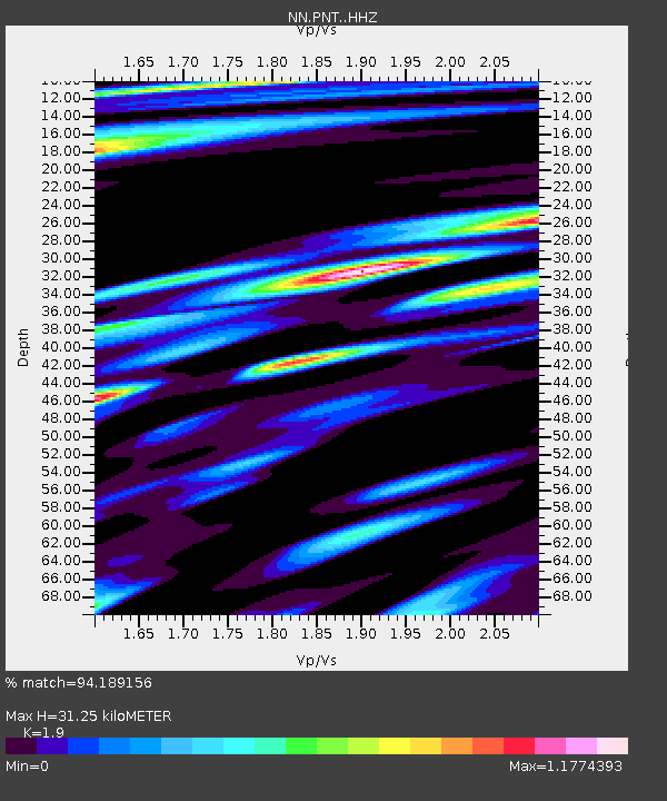
| Estimated Moho Depth: |
31.25 km |
| Estimated Crust Vp/Vs: |
1.90 |
| Assumed Crust Vp: |
6.279 km/s |
| Estimated Crust Vs: |
3.305 km/s |
| Estimated Crust Poisson's Ratio: |
0.31 |
|
| Radial Match: |
94.189156 % |
| Radial Bump: |
363 |
| Transverse Match: |
77.120735 % |
| Transverse Bump: |
400 |
| SOD ConfigId: |
30536071 |
| Insert Time: |
2023-07-30 07:22:01.377 +0000 |
| GWidth: |
2.5 |
| Max Bumps: |
400 |
| Tol: |
0.001 |
|

Signal To Noise
| Channel | StoN | STA | LTA |
| NN:PNT: :HHZ:20230716T06:54:11.683014Z | 6.17748 | 7.9943345E-7 | 1.2941094E-7 |
| NN:PNT: :HHN:20230716T06:54:11.683014Z | 3.1066558 | 3.451266E-7 | 1.1109264E-7 |
| NN:PNT: :HHE:20230716T06:54:11.683014Z | 2.7521892 | 3.1851545E-7 | 1.15731666E-7 |
| Arrivals |
| Ps | 4.8 SECOND |
| PpPs | 13 SECOND |
| PsPs/PpSs | 18 SECOND |


