You are here: Home > Network List > O2 - Oklahoma Consolidated Temporary Seismic Networks Stations List
> Station PW10 Pawnee, Oklahoma > Earthquake Result Viewer
PW10 Pawnee, Oklahoma - Earthquake Result Viewer
| Earthquake location: |
Alaska Peninsula |
| Earthquake latitude/longitude: |
54.5/-160.8 |
| Earthquake time(UTC): |
2023/07/16 (197) 06:48:21 GMT |
| Earthquake Depth: |
21 km |
| Earthquake Magnitude: |
7.3 Mi |
| Earthquake Catalog/Contributor: |
NEIC PDE/at |
|
| Network: |
O2 Oklahoma Consolidated Temporary Seismic Networks |
| Station: |
PW10 Pawnee, Oklahoma |
| Lat/Lon: |
36.37 N/96.83 W |
| Elevation: |
297 m |
|
| Distance: |
46.7 deg |
| Az: |
85.53 deg |
| Baz: |
313.893 deg |
| Ray Param: |
0.070471786 |
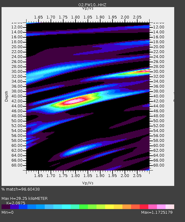
| Estimated Moho Depth: |
29.25 km |
| Estimated Crust Vp/Vs: |
2.10 |
| Assumed Crust Vp: |
6.483 km/s |
| Estimated Crust Vs: |
3.091 km/s |
| Estimated Crust Poisson's Ratio: |
0.35 |
|
| Radial Match: |
96.60438 % |
| Radial Bump: |
341 |
| Transverse Match: |
94.83198 % |
| Transverse Bump: |
400 |
| SOD ConfigId: |
30536071 |
| Insert Time: |
2023-07-30 07:24:19.329 +0000 |
| GWidth: |
2.5 |
| Max Bumps: |
400 |
| Tol: |
0.001 |
|

Signal To Noise
| Channel | StoN | STA | LTA |
| O2:PW10: :HHZ:20230716T06:56:17.195007Z | 20.40931 | 1.2737403E-6 | 6.2409775E-8 |
| O2:PW10: :HHN:20230716T06:56:17.195007Z | 9.352197 | 3.612919E-7 | 3.863177E-8 |
| O2:PW10: :HHE:20230716T06:56:17.195007Z | 14.9021635 | 8.0040604E-7 | 5.3710725E-8 |
| Arrivals |
| Ps | 5.2 SECOND |
| PpPs | 13 SECOND |
| PsPs/PpSs | 18 SECOND |


