You are here: Home > Network List > O2 - Oklahoma Consolidated Temporary Seismic Networks Stations List
> Station SC15 Hammon, Oklahoma, USA > Earthquake Result Viewer
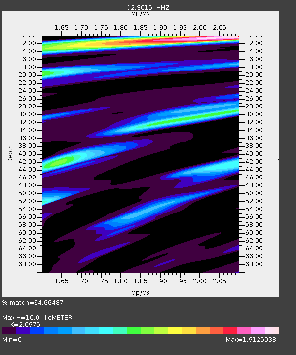
SC15 Hammon, Oklahoma, USA - Earthquake Result Viewer
| Earthquake location: |
Alaska Peninsula |
| Earthquake latitude/longitude: |
54.5/-160.8 |
| Earthquake time(UTC): |
2023/07/16 (197) 06:48:21 GMT |
| Earthquake Depth: |
21 km |
| Earthquake Magnitude: |
7.3 Mi |
| Earthquake Catalog/Contributor: |
NEIC PDE/at |
|
| Network: |
O2 Oklahoma Consolidated Temporary Seismic Networks |
| Station: |
SC15 Hammon, Oklahoma, USA |
| Lat/Lon: |
35.61 N/99.50 W |
| Elevation: |
550 m |
|
| Distance: |
45.6 deg |
| Az: |
88.372 deg |
| Baz: |
314.301 deg |
| Ray Param: |
0.07111357 |
| Estimated Moho Depth: |
10.0 km |
| Estimated Crust Vp/Vs: |
2.10 |
| Assumed Crust Vp: |
6.315 km/s |
| Estimated Crust Vs: |
3.011 km/s |
| Estimated Crust Poisson's Ratio: |
0.35 |
|
| Radial Match: |
94.66487 % |
| Radial Bump: |
341 |
| Transverse Match: |
82.56711 % |
| Transverse Bump: |
400 |
| SOD ConfigId: |
30536071 |
| Insert Time: |
2023-07-30 07:25:06.308 +0000 |
| GWidth: |
2.5 |
| Max Bumps: |
400 |
| Tol: |
0.001 |
|

Signal To Noise
| Channel | StoN | STA | LTA |
| O2:SC15: :HHZ:20230716T06:56:09.11499Z | 10.045959 | 1.4296357E-6 | 1.4230953E-7 |
| O2:SC15: :HHN:20230716T06:56:09.11499Z | 3.3643205 | 4.2751876E-7 | 1.2707432E-7 |
| O2:SC15: :HHE:20230716T06:56:09.11499Z | 2.3963766 | 4.2336035E-7 | 1.7666687E-7 |
| Arrivals |
| Ps | 1.8 SECOND |
| PpPs | 4.7 SECOND |
| PsPs/PpSs | 6.5 SECOND |


