You are here: Home > Network List > O2 - Oklahoma Consolidated Temporary Seismic Networks Stations List
> Station STIG Stigler, Oklahoma, USA > Earthquake Result Viewer
STIG Stigler, Oklahoma, USA - Earthquake Result Viewer
| Earthquake location: |
Alaska Peninsula |
| Earthquake latitude/longitude: |
54.5/-160.8 |
| Earthquake time(UTC): |
2023/07/16 (197) 06:48:21 GMT |
| Earthquake Depth: |
21 km |
| Earthquake Magnitude: |
7.3 Mi |
| Earthquake Catalog/Contributor: |
NEIC PDE/at |
|
| Network: |
O2 Oklahoma Consolidated Temporary Seismic Networks |
| Station: |
STIG Stigler, Oklahoma, USA |
| Lat/Lon: |
35.34 N/95.11 W |
| Elevation: |
256 m |
|
| Distance: |
48.4 deg |
| Az: |
85.195 deg |
| Baz: |
314.674 deg |
| Ray Param: |
0.06936677 |
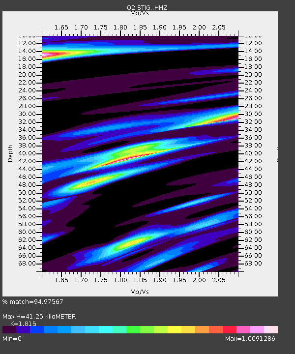
| Estimated Moho Depth: |
41.25 km |
| Estimated Crust Vp/Vs: |
1.82 |
| Assumed Crust Vp: |
6.498 km/s |
| Estimated Crust Vs: |
3.58 km/s |
| Estimated Crust Poisson's Ratio: |
0.28 |
|
| Radial Match: |
94.97567 % |
| Radial Bump: |
400 |
| Transverse Match: |
77.770515 % |
| Transverse Bump: |
400 |
| SOD ConfigId: |
30536071 |
| Insert Time: |
2023-07-30 07:25:20.502 +0000 |
| GWidth: |
2.5 |
| Max Bumps: |
400 |
| Tol: |
0.001 |
|

Signal To Noise
| Channel | StoN | STA | LTA |
| O2:STIG: :HHZ:20230716T06:56:30.515015Z | 21.828894 | 1.662928E-6 | 7.618013E-8 |
| O2:STIG: :HHN:20230716T06:56:30.515015Z | 1.4767395 | 4.2421289E-7 | 2.8726316E-7 |
| O2:STIG: :HHE:20230716T06:56:30.515015Z | 2.6304126 | 8.0364134E-7 | 3.0551914E-7 |
| Arrivals |
| Ps | 5.5 SECOND |
| PpPs | 17 SECOND |
| PsPs/PpSs | 22 SECOND |


