You are here: Home > Network List > OK - Oklahoma Seismic Network Stations List
> Station CROK Carrier, Oklahoma > Earthquake Result Viewer
CROK Carrier, Oklahoma - Earthquake Result Viewer
| Earthquake location: |
Alaska Peninsula |
| Earthquake latitude/longitude: |
54.5/-160.8 |
| Earthquake time(UTC): |
2023/07/16 (197) 06:48:21 GMT |
| Earthquake Depth: |
21 km |
| Earthquake Magnitude: |
7.3 Mi |
| Earthquake Catalog/Contributor: |
NEIC PDE/at |
|
| Network: |
OK Oklahoma Seismic Network |
| Station: |
CROK Carrier, Oklahoma |
| Lat/Lon: |
36.50 N/97.98 W |
| Elevation: |
403 m |
|
| Distance: |
45.9 deg |
| Az: |
86.281 deg |
| Baz: |
313.731 deg |
| Ray Param: |
0.070961915 |
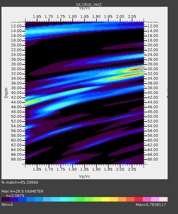
| Estimated Moho Depth: |
29.5 km |
| Estimated Crust Vp/Vs: |
2.10 |
| Assumed Crust Vp: |
6.483 km/s |
| Estimated Crust Vs: |
3.091 km/s |
| Estimated Crust Poisson's Ratio: |
0.35 |
|
| Radial Match: |
95.28988 % |
| Radial Bump: |
283 |
| Transverse Match: |
84.283264 % |
| Transverse Bump: |
400 |
| SOD ConfigId: |
30536071 |
| Insert Time: |
2023-07-30 07:26:12.486 +0000 |
| GWidth: |
2.5 |
| Max Bumps: |
400 |
| Tol: |
0.001 |
|

Signal To Noise
| Channel | StoN | STA | LTA |
| OK:CROK: :HHZ:20230716T06:56:11.179993Z | 6.643951 | 1.1964806E-6 | 1.800857E-7 |
| OK:CROK: :HHN:20230716T06:56:11.179993Z | 1.7596548 | 5.085743E-7 | 2.8901937E-7 |
| OK:CROK: :HHE:20230716T06:56:11.179993Z | 2.6710033 | 5.5473447E-7 | 2.0768768E-7 |
| Arrivals |
| Ps | 5.3 SECOND |
| PpPs | 13 SECOND |
| PsPs/PpSs | 19 SECOND |


