You are here: Home > Network List > PR - Puerto Rico Seismic Network (PRSN) & Puerto Rico Strong Motion Program (PRSMP) Stations List
> Station IGPR Inter Guayama > Earthquake Result Viewer
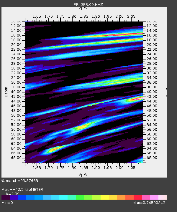
IGPR Inter Guayama - Earthquake Result Viewer
| Earthquake location: |
Alaska Peninsula |
| Earthquake latitude/longitude: |
54.5/-160.8 |
| Earthquake time(UTC): |
2023/07/16 (197) 06:48:21 GMT |
| Earthquake Depth: |
21 km |
| Earthquake Magnitude: |
7.3 Mi |
| Earthquake Catalog/Contributor: |
NEIC PDE/at |
|
| Network: |
PR Puerto Rico Seismic Network (PRSN) & Puerto Rico Strong Motion Program (PRSMP) |
| Station: |
IGPR Inter Guayama |
| Lat/Lon: |
17.97 N/66.11 W |
| Elevation: |
10 m |
|
| Distance: |
78.3 deg |
| Az: |
75.686 deg |
| Baz: |
323.565 deg |
| Ray Param: |
0.049754165 |
| Estimated Moho Depth: |
42.5 km |
| Estimated Crust Vp/Vs: |
2.09 |
| Assumed Crust Vp: |
4.082 km/s |
| Estimated Crust Vs: |
1.953 km/s |
| Estimated Crust Poisson's Ratio: |
0.35 |
|
| Radial Match: |
93.37665 % |
| Radial Bump: |
256 |
| Transverse Match: |
88.49812 % |
| Transverse Bump: |
400 |
| SOD ConfigId: |
30536071 |
| Insert Time: |
2023-07-30 07:28:35.069 +0000 |
| GWidth: |
2.5 |
| Max Bumps: |
400 |
| Tol: |
0.001 |
|

Signal To Noise
| Channel | StoN | STA | LTA |
| PR:IGPR:00:HHZ:20230716T06:59:47.840027Z | 21.0675 | 2.3992054E-6 | 1.1388183E-7 |
| PR:IGPR:00:HH1:20230716T06:59:47.840027Z | 5.4492936 | 6.1905894E-7 | 1.1360352E-7 |
| PR:IGPR:00:HH2:20230716T06:59:47.840027Z | 5.0492167 | 6.049874E-7 | 1.1981807E-7 |
| Arrivals |
| Ps | 11 SECOND |
| PpPs | 32 SECOND |
| PsPs/PpSs | 43 SECOND |


