You are here: Home > Network List > SB - UC Santa Barbara Engineering Seismology Network () Stations List
> Station VAFB1 Globe Rd, Vandenberg AFB, CA, USA > Earthquake Result Viewer
VAFB1 Globe Rd, Vandenberg AFB, CA, USA - Earthquake Result Viewer
| Earthquake location: |
Alaska Peninsula |
| Earthquake latitude/longitude: |
54.5/-160.8 |
| Earthquake time(UTC): |
2023/07/16 (197) 06:48:21 GMT |
| Earthquake Depth: |
21 km |
| Earthquake Magnitude: |
7.3 Mi |
| Earthquake Catalog/Contributor: |
NEIC PDE/at |
|
| Network: |
SB UC Santa Barbara Engineering Seismology Network () |
| Station: |
VAFB1 Globe Rd, Vandenberg AFB, CA, USA |
| Lat/Lon: |
34.86 N/120.60 W |
| Elevation: |
121 m |
|
| Distance: |
34.0 deg |
| Az: |
108.56 deg |
| Baz: |
317.735 deg |
| Ray Param: |
0.07791205 |
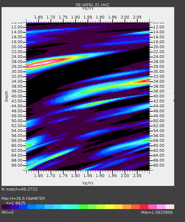
| Estimated Moho Depth: |
26.5 km |
| Estimated Crust Vp/Vs: |
1.66 |
| Assumed Crust Vp: |
6.183 km/s |
| Estimated Crust Vs: |
3.719 km/s |
| Estimated Crust Poisson's Ratio: |
0.22 |
|
| Radial Match: |
95.2722 % |
| Radial Bump: |
400 |
| Transverse Match: |
81.4934 % |
| Transverse Bump: |
400 |
| SOD ConfigId: |
30536071 |
| Insert Time: |
2023-07-30 07:30:56.983 +0000 |
| GWidth: |
2.5 |
| Max Bumps: |
400 |
| Tol: |
0.001 |
|

Signal To Noise
| Channel | StoN | STA | LTA |
| SB:VAFB1:01:HHZ:20230716T06:54:32.959991Z | 4.2690496 | 1.4177901E-6 | 3.321091E-7 |
| SB:VAFB1:01:HHN:20230716T06:54:32.959991Z | 2.4983077 | 7.555293E-7 | 3.0241642E-7 |
| SB:VAFB1:01:HHE:20230716T06:54:32.959991Z | 2.1009543 | 7.4751114E-7 | 3.55796E-7 |
| Arrivals |
| Ps | 3.1 SECOND |
| PpPs | 11 SECOND |
| PsPs/PpSs | 14 SECOND |


