You are here: Home > Network List > SC - New Mexico Tech Seismic Network Stations List
> Station GDL2 Guadalupe Mountains, New Mexico > Earthquake Result Viewer
GDL2 Guadalupe Mountains, New Mexico - Earthquake Result Viewer
| Earthquake location: |
Alaska Peninsula |
| Earthquake latitude/longitude: |
54.5/-160.8 |
| Earthquake time(UTC): |
2023/07/16 (197) 06:48:21 GMT |
| Earthquake Depth: |
21 km |
| Earthquake Magnitude: |
7.3 Mi |
| Earthquake Catalog/Contributor: |
NEIC PDE/at |
|
| Network: |
SC New Mexico Tech Seismic Network |
| Station: |
GDL2 Guadalupe Mountains, New Mexico |
| Lat/Lon: |
32.20 N/104.36 W |
| Elevation: |
1211 m |
|
| Distance: |
45.2 deg |
| Az: |
95.764 deg |
| Baz: |
316.788 deg |
| Ray Param: |
0.071389675 |
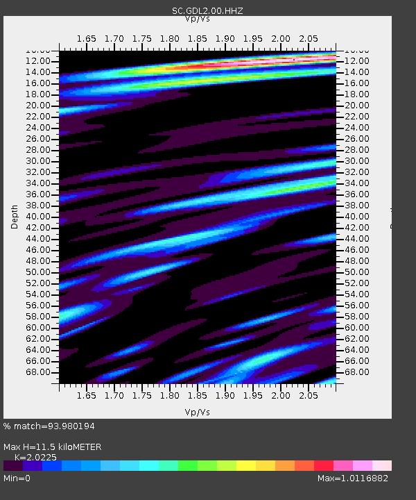
| Estimated Moho Depth: |
11.5 km |
| Estimated Crust Vp/Vs: |
2.02 |
| Assumed Crust Vp: |
6.232 km/s |
| Estimated Crust Vs: |
3.081 km/s |
| Estimated Crust Poisson's Ratio: |
0.34 |
|
| Radial Match: |
93.980194 % |
| Radial Bump: |
400 |
| Transverse Match: |
88.06338 % |
| Transverse Bump: |
400 |
| SOD ConfigId: |
30536071 |
| Insert Time: |
2023-07-30 07:31:08.592 +0000 |
| GWidth: |
2.5 |
| Max Bumps: |
400 |
| Tol: |
0.001 |
|

Signal To Noise
| Channel | StoN | STA | LTA |
| SC:GDL2:00:HHZ:20230716T06:56:05.86499Z | 13.997986 | 4.1480437E-8 | 2.9633147E-9 |
| SC:GDL2:00:HHN:20230716T06:56:05.86499Z | 9.075586 | 1.5578744E-8 | 1.7165551E-9 |
| SC:GDL2:00:HHE:20230716T06:56:05.86499Z | 5.7351375 | 1.1799597E-8 | 2.0574218E-9 |
| Arrivals |
| Ps | 2.0 SECOND |
| PpPs | 5.3 SECOND |
| PsPs/PpSs | 7.3 SECOND |


