You are here: Home > Network List > TX - Texas Seismological Network Stations List
> Station SNAG San Augustine > Earthquake Result Viewer
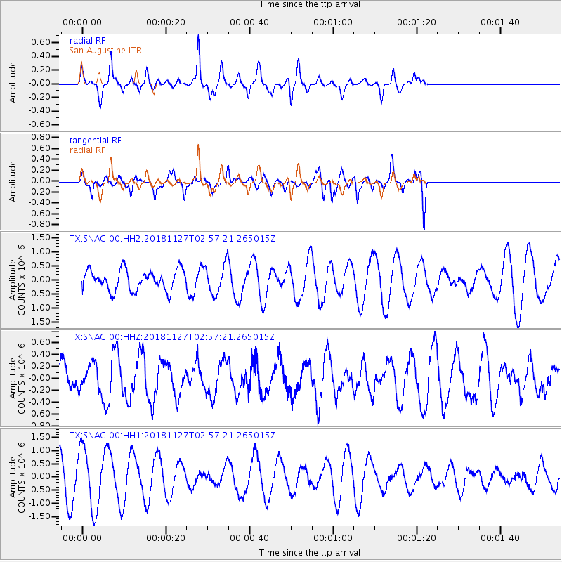
SNAG San Augustine - Earthquake Result Viewer
*The percent match for this event was below the threshold and hence no stack was calculated.
| Earthquake location: |
Fiji Islands Region |
| Earthquake latitude/longitude: |
-17.9/-178.6 |
| Earthquake time(UTC): |
2018/11/27 (331) 02:45:32 GMT |
| Earthquake Depth: |
568 km |
| Earthquake Magnitude: |
5.6 Mww |
| Earthquake Catalog/Contributor: |
NEIC PDE/us |
|
| Network: |
TX Texas Seismological Network |
| Station: |
SNAG San Augustine |
| Lat/Lon: |
31.52 N/94.18 W |
| Elevation: |
84 m |
|
| Distance: |
94.5 deg |
| Az: |
58.499 deg |
| Baz: |
251.934 deg |
| Ray Param: |
$rayparam |
*The percent match for this event was below the threshold and hence was not used in the summary stack. |
|
| Radial Match: |
30.05945 % |
| Radial Bump: |
227 |
| Transverse Match: |
80.6729 % |
| Transverse Bump: |
393 |
| SOD ConfigId: |
3165032 |
| Insert Time: |
2018-12-11 02:52:23.509 +0000 |
| GWidth: |
2.5 |
| Max Bumps: |
400 |
| Tol: |
0.001 |
|
Signal To Noise
| Channel | StoN | STA | LTA |
| TX:SNAG:00:HHZ:20181127T02:57:21.265015Z | 0.5633162 | 2.207523E-7 | 3.9187987E-7 |
| TX:SNAG:00:HH1:20181127T02:57:21.265015Z | 2.9273136 | 1.1382989E-6 | 3.8885446E-7 |
| TX:SNAG:00:HH2:20181127T02:57:21.265015Z | 1.4516189 | 5.2229825E-7 | 3.5980395E-7 |
| Arrivals |
| Ps | |
| PpPs | |
| PsPs/PpSs | |


