You are here: Home > Network List > TX - Texas Seismological Network Stations List
> Station PB28 Culberson South > Earthquake Result Viewer
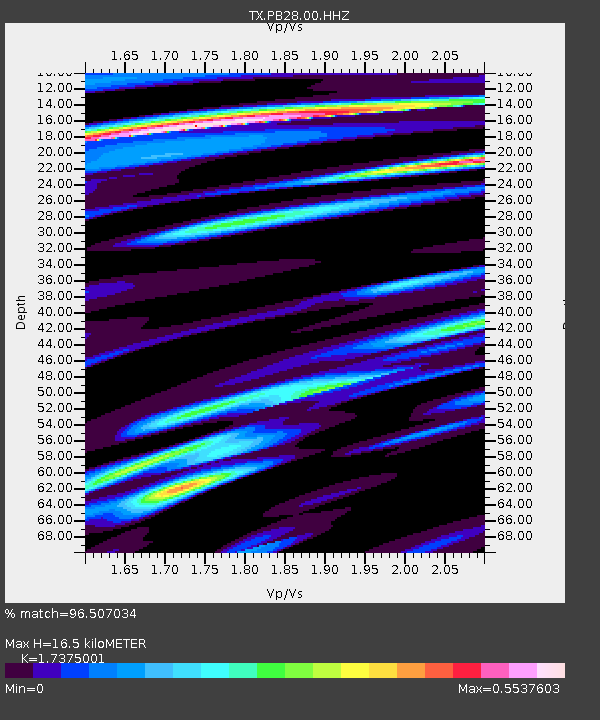
PB28 Culberson South - Earthquake Result Viewer
| Earthquake location: |
Alaska Peninsula |
| Earthquake latitude/longitude: |
54.5/-160.8 |
| Earthquake time(UTC): |
2023/07/16 (197) 06:48:21 GMT |
| Earthquake Depth: |
21 km |
| Earthquake Magnitude: |
7.3 Mi |
| Earthquake Catalog/Contributor: |
NEIC PDE/at |
|
| Network: |
TX Texas Seismological Network |
| Station: |
PB28 Culberson South |
| Lat/Lon: |
31.67 N/104.50 W |
| Elevation: |
1204 m |
|
| Distance: |
45.5 deg |
| Az: |
96.392 deg |
| Baz: |
317.157 deg |
| Ray Param: |
0.07118305 |
| Estimated Moho Depth: |
16.5 km |
| Estimated Crust Vp/Vs: |
1.74 |
| Assumed Crust Vp: |
6.361 km/s |
| Estimated Crust Vs: |
3.661 km/s |
| Estimated Crust Poisson's Ratio: |
0.25 |
|
| Radial Match: |
96.507034 % |
| Radial Bump: |
260 |
| Transverse Match: |
86.2466 % |
| Transverse Bump: |
400 |
| SOD ConfigId: |
30536071 |
| Insert Time: |
2023-07-30 07:33:56.056 +0000 |
| GWidth: |
2.5 |
| Max Bumps: |
400 |
| Tol: |
0.001 |
|

Signal To Noise
| Channel | StoN | STA | LTA |
| TX:PB28:00:HHZ:20230716T06:56:08.309998Z | 4.621106 | 2.4475662E-7 | 5.2964946E-8 |
| TX:PB28:00:HH1:20230716T06:56:08.309998Z | 2.920652 | 8.034889E-8 | 2.75106E-8 |
| TX:PB28:00:HH2:20230716T06:56:08.309998Z | 3.0924582 | 9.3285564E-8 | 3.0165506E-8 |
| Arrivals |
| Ps | 2.0 SECOND |
| PpPs | 6.7 SECOND |
| PsPs/PpSs | 8.7 SECOND |


