You are here: Home > Network List > TX - Texas Seismological Network Stations List
> Station SAND Sanderson > Earthquake Result Viewer
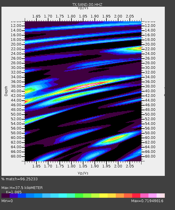
SAND Sanderson - Earthquake Result Viewer
| Earthquake location: |
Alaska Peninsula |
| Earthquake latitude/longitude: |
54.5/-160.8 |
| Earthquake time(UTC): |
2023/07/16 (197) 06:48:21 GMT |
| Earthquake Depth: |
21 km |
| Earthquake Magnitude: |
7.3 Mi |
| Earthquake Catalog/Contributor: |
NEIC PDE/at |
|
| Network: |
TX Texas Seismological Network |
| Station: |
SAND Sanderson |
| Lat/Lon: |
29.95 N/102.12 W |
| Elevation: |
689 m |
|
| Distance: |
48.2 deg |
| Az: |
95.901 deg |
| Baz: |
318.033 deg |
| Ray Param: |
0.06950246 |
| Estimated Moho Depth: |
37.5 km |
| Estimated Crust Vp/Vs: |
1.87 |
| Assumed Crust Vp: |
6.419 km/s |
| Estimated Crust Vs: |
3.442 km/s |
| Estimated Crust Poisson's Ratio: |
0.30 |
|
| Radial Match: |
96.25233 % |
| Radial Bump: |
395 |
| Transverse Match: |
84.24927 % |
| Transverse Bump: |
400 |
| SOD ConfigId: |
30536071 |
| Insert Time: |
2023-07-30 07:34:11.334 +0000 |
| GWidth: |
2.5 |
| Max Bumps: |
400 |
| Tol: |
0.001 |
|

Signal To Noise
| Channel | StoN | STA | LTA |
| TX:SAND:00:HHZ:20230716T06:56:28.920013Z | 6.1708865 | 2.9187265E-7 | 4.7298332E-8 |
| TX:SAND:00:HH1:20230716T06:56:28.920013Z | 2.0126255 | 5.4261708E-8 | 2.6960658E-8 |
| TX:SAND:00:HH2:20230716T06:56:28.920013Z | 3.572405 | 1.7433105E-7 | 4.879935E-8 |
| Arrivals |
| Ps | 5.4 SECOND |
| PpPs | 16 SECOND |
| PsPs/PpSs | 21 SECOND |


