You are here: Home > Network List > US - United States National Seismic Network Stations List
> Station TZTN Tazewell, Tennessee, USA > Earthquake Result Viewer
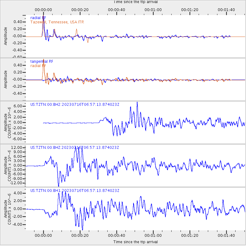
TZTN Tazewell, Tennessee, USA - Earthquake Result Viewer

| Earthquake location: |
Alaska Peninsula |
| Earthquake latitude/longitude: |
54.5/-160.8 |
| Earthquake time(UTC): |
2023/07/16 (197) 06:48:21 GMT |
| Earthquake Depth: |
21 km |
| Earthquake Magnitude: |
7.3 Mi |
| Earthquake Catalog/Contributor: |
NEIC PDE/at |
|
| Network: |
US United States National Seismic Network |
| Station: |
TZTN Tazewell, Tennessee, USA |
| Lat/Lon: |
36.54 N/83.55 W |
| Elevation: |
394 m |
|
| Distance: |
54.2 deg |
| Az: |
75.611 deg |
| Baz: |
315.432 deg |
| Ray Param: |
0.06559464 |
| Estimated Moho Depth: |
13.25 km |
| Estimated Crust Vp/Vs: |
1.96 |
| Assumed Crust Vp: |
6.476 km/s |
| Estimated Crust Vs: |
3.312 km/s |
| Estimated Crust Poisson's Ratio: |
0.32 |
|
| Radial Match: |
97.92184 % |
| Radial Bump: |
400 |
| Transverse Match: |
92.84808 % |
| Transverse Bump: |
400 |
| SOD ConfigId: |
30536071 |
| Insert Time: |
2023-07-30 07:36:31.881 +0000 |
| GWidth: |
2.5 |
| Max Bumps: |
400 |
| Tol: |
0.001 |
|
Signal To Noise
| Channel | StoN | STA | LTA |
| US:TZTN:00:BHZ:20230716T06:57:13.874023Z | 38.36016 | 3.078693E-6 | 8.025756E-8 |
| US:TZTN:00:BH1:20230716T06:57:13.874023Z | 24.01685 | 1.1668708E-6 | 4.858551E-8 |
| US:TZTN:00:BH2:20230716T06:57:13.874023Z | 26.222635 | 1.1459761E-6 | 4.370179E-8 |
| Arrivals |
| Ps | 2.1 SECOND |
| PpPs | 5.8 SECOND |
| PsPs/PpSs | 7.8 SECOND |


