You are here: Home > Network List > UU - University of Utah Regional Network Stations List
> Station FOR8 FORGE > Earthquake Result Viewer
FOR8 FORGE - Earthquake Result Viewer
| Earthquake location: |
Alaska Peninsula |
| Earthquake latitude/longitude: |
54.5/-160.8 |
| Earthquake time(UTC): |
2023/07/16 (197) 06:48:21 GMT |
| Earthquake Depth: |
21 km |
| Earthquake Magnitude: |
7.3 Mi |
| Earthquake Catalog/Contributor: |
NEIC PDE/at |
|
| Network: |
UU University of Utah Regional Network |
| Station: |
FOR8 FORGE |
| Lat/Lon: |
38.53 N/113.08 W |
| Elevation: |
1654 m |
|
| Distance: |
35.7 deg |
| Az: |
96.551 deg |
| Baz: |
312.354 deg |
| Ray Param: |
0.07703786 |
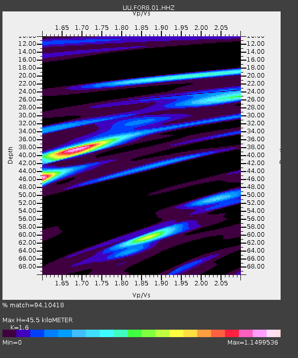
| Estimated Moho Depth: |
45.5 km |
| Estimated Crust Vp/Vs: |
1.60 |
| Assumed Crust Vp: |
6.276 km/s |
| Estimated Crust Vs: |
3.922 km/s |
| Estimated Crust Poisson's Ratio: |
0.18 |
|
| Radial Match: |
94.10418 % |
| Radial Bump: |
228 |
| Transverse Match: |
71.842545 % |
| Transverse Bump: |
400 |
| SOD ConfigId: |
30536071 |
| Insert Time: |
2023-07-30 07:37:01.453 +0000 |
| GWidth: |
2.5 |
| Max Bumps: |
400 |
| Tol: |
0.001 |
|

Signal To Noise
| Channel | StoN | STA | LTA |
| UU:FOR8:01:HHZ:20230716T06:54:47.51001Z | 4.937063 | 4.9291344E-7 | 9.9839404E-8 |
| UU:FOR8:01:HHN:20230716T06:54:47.51001Z | 2.169134 | 1.491413E-7 | 6.875615E-8 |
| UU:FOR8:01:HHE:20230716T06:54:47.51001Z | 4.053067 | 2.6811688E-7 | 6.61516E-8 |
| Arrivals |
| Ps | 4.7 SECOND |
| PpPs | 17 SECOND |
| PsPs/PpSs | 22 SECOND |


