You are here: Home > Network List > UU - University of Utah Regional Network Stations List
> Station MOUT Mount Ogden, UT, USA > Earthquake Result Viewer
MOUT Mount Ogden, UT, USA - Earthquake Result Viewer
| Earthquake location: |
Alaska Peninsula |
| Earthquake latitude/longitude: |
54.5/-160.8 |
| Earthquake time(UTC): |
2023/07/16 (197) 06:48:21 GMT |
| Earthquake Depth: |
21 km |
| Earthquake Magnitude: |
7.3 Mi |
| Earthquake Catalog/Contributor: |
NEIC PDE/at |
|
| Network: |
UU University of Utah Regional Network |
| Station: |
MOUT Mount Ogden, UT, USA |
| Lat/Lon: |
41.20 N/111.88 W |
| Elevation: |
2748 m |
|
| Distance: |
34.7 deg |
| Az: |
92.006 deg |
| Baz: |
309.405 deg |
| Ray Param: |
0.077593386 |
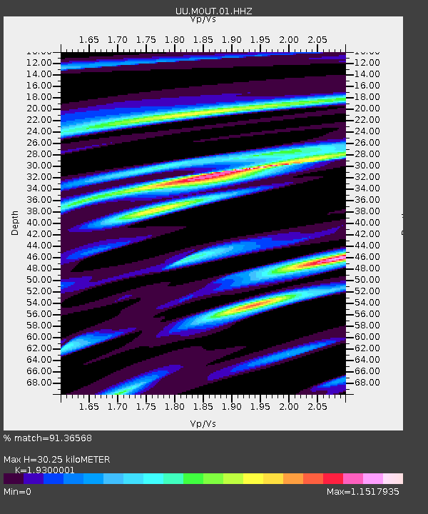
| Estimated Moho Depth: |
30.25 km |
| Estimated Crust Vp/Vs: |
1.93 |
| Assumed Crust Vp: |
6.155 km/s |
| Estimated Crust Vs: |
3.189 km/s |
| Estimated Crust Poisson's Ratio: |
0.32 |
|
| Radial Match: |
91.36568 % |
| Radial Bump: |
400 |
| Transverse Match: |
80.28718 % |
| Transverse Bump: |
400 |
| SOD ConfigId: |
30536071 |
| Insert Time: |
2023-07-30 07:37:14.377 +0000 |
| GWidth: |
2.5 |
| Max Bumps: |
400 |
| Tol: |
0.001 |
|

Signal To Noise
| Channel | StoN | STA | LTA |
| UU:MOUT:01:HHZ:20230716T06:54:38.51001Z | 4.8131027 | 2.462943E-7 | 5.117163E-8 |
| UU:MOUT:01:HHN:20230716T06:54:38.51001Z | 1.6234341 | 1.06399355E-7 | 6.553969E-8 |
| UU:MOUT:01:HHE:20230716T06:54:38.51001Z | 2.869403 | 1.6905938E-7 | 5.8917962E-8 |
| Arrivals |
| Ps | 4.9 SECOND |
| PpPs | 14 SECOND |
| PsPs/PpSs | 18 SECOND |


