You are here: Home > Network List > UU - University of Utah Regional Network Stations List
> Station BEID Bear River Idaho > Earthquake Result Viewer
BEID Bear River Idaho - Earthquake Result Viewer
| Earthquake location: |
Alaska Peninsula |
| Earthquake latitude/longitude: |
54.5/-160.8 |
| Earthquake time(UTC): |
2023/07/16 (197) 06:48:21 GMT |
| Earthquake Depth: |
21 km |
| Earthquake Magnitude: |
7.3 Mi |
| Earthquake Catalog/Contributor: |
NEIC PDE/at |
|
| Network: |
UU University of Utah Regional Network |
| Station: |
BEID Bear River Idaho |
| Lat/Lon: |
42.12 N/111.78 W |
| Elevation: |
1864 m |
|
| Distance: |
34.2 deg |
| Az: |
90.663 deg |
| Baz: |
308.362 deg |
| Ray Param: |
0.07785134 |
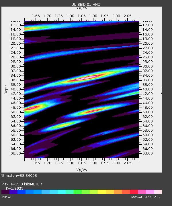
| Estimated Moho Depth: |
35.0 km |
| Estimated Crust Vp/Vs: |
1.86 |
| Assumed Crust Vp: |
6.207 km/s |
| Estimated Crust Vs: |
3.332 km/s |
| Estimated Crust Poisson's Ratio: |
0.30 |
|
| Radial Match: |
88.34098 % |
| Radial Bump: |
400 |
| Transverse Match: |
80.641975 % |
| Transverse Bump: |
400 |
| SOD ConfigId: |
30536071 |
| Insert Time: |
2023-07-30 07:37:32.784 +0000 |
| GWidth: |
2.5 |
| Max Bumps: |
400 |
| Tol: |
0.001 |
|

Signal To Noise
| Channel | StoN | STA | LTA |
| UU:BEID:01:HHZ:20230716T06:54:34.019989Z | 6.7064757 | 3.966675E-7 | 5.9146938E-8 |
| UU:BEID:01:HHN:20230716T06:54:34.019989Z | 4.5881915 | 1.7770532E-7 | 3.8731017E-8 |
| UU:BEID:01:HHE:20230716T06:54:34.019989Z | 2.9652236 | 1.6547102E-7 | 5.5803895E-8 |
| Arrivals |
| Ps | 5.2 SECOND |
| PpPs | 15 SECOND |
| PsPs/PpSs | 20 SECOND |


