You are here: Home > Network List > WI - West Indies IPGP Network Stations List
> Station BIM Morne Bigot, Anses d'Arlets, Martinique > Earthquake Result Viewer
BIM Morne Bigot, Anses d'Arlets, Martinique - Earthquake Result Viewer

| Earthquake location: |
Alaska Peninsula |
| Earthquake latitude/longitude: |
54.5/-160.8 |
| Earthquake time(UTC): |
2023/07/16 (197) 06:48:21 GMT |
| Earthquake Depth: |
21 km |
| Earthquake Magnitude: |
7.3 Mi |
| Earthquake Catalog/Contributor: |
NEIC PDE/at |
|
| Network: |
WI West Indies IPGP Network |
| Station: |
BIM Morne Bigot, Anses d'Arlets, Martinique |
| Lat/Lon: |
14.52 N/61.07 W |
| Elevation: |
391 m |
|
| Distance: |
83.9 deg |
| Az: |
73.747 deg |
| Baz: |
324.666 deg |
| Ray Param: |
0.045863647 |
| Estimated Moho Depth: |
10.75 km |
| Estimated Crust Vp/Vs: |
1.71 |
| Assumed Crust Vp: |
5.88 km/s |
| Estimated Crust Vs: |
3.444 km/s |
| Estimated Crust Poisson's Ratio: |
0.24 |
|
| Radial Match: |
89.88158 % |
| Radial Bump: |
400 |
| Transverse Match: |
77.91846 % |
| Transverse Bump: |
400 |
| SOD ConfigId: |
30536071 |
| Insert Time: |
2023-07-30 07:37:56.724 +0000 |
| GWidth: |
2.5 |
| Max Bumps: |
400 |
| Tol: |
0.001 |
|
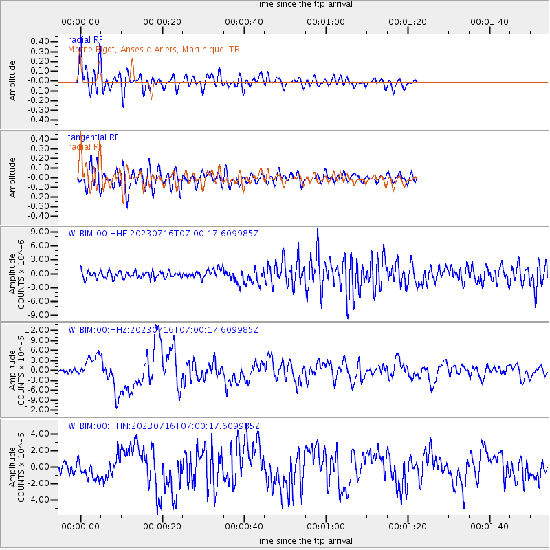
Signal To Noise
| Channel | StoN | STA | LTA |
| WI:BIM:00:HHZ:20230716T07:00:17.609985Z | 7.87036 | 3.357046E-6 | 4.265429E-7 |
| WI:BIM:00:HHN:20230716T07:00:17.609985Z | 2.1046875 | 1.0933857E-6 | 5.1950025E-7 |
| WI:BIM:00:HHE:20230716T07:00:17.609985Z | 1.5585213 | 1.1010275E-6 | 7.0645655E-7 |
| Arrivals |
| Ps | 1.3 SECOND |
| PpPs | 4.8 SECOND |
| PsPs/PpSs | 6.2 SECOND |


