You are here: Home > Network List > YU19 - Cornell University Earth Source Heat seismic network (Cornell_ESH (2019-2024)) Stations List
> Station B01A Lansing > Earthquake Result Viewer
B01A Lansing - Earthquake Result Viewer
| Earthquake location: |
Alaska Peninsula |
| Earthquake latitude/longitude: |
54.5/-160.8 |
| Earthquake time(UTC): |
2023/07/16 (197) 06:48:21 GMT |
| Earthquake Depth: |
21 km |
| Earthquake Magnitude: |
7.3 Mi |
| Earthquake Catalog/Contributor: |
NEIC PDE/at |
|
| Network: |
YU Cornell University Earth Source Heat seismic network (Cornell_ESH (2019-2024)) |
| Station: |
B01A Lansing |
| Lat/Lon: |
42.55 N/76.51 W |
| Elevation: |
271 m |
|
| Distance: |
53.8 deg |
| Az: |
65.606 deg |
| Baz: |
314.019 deg |
| Ray Param: |
0.065812506 |
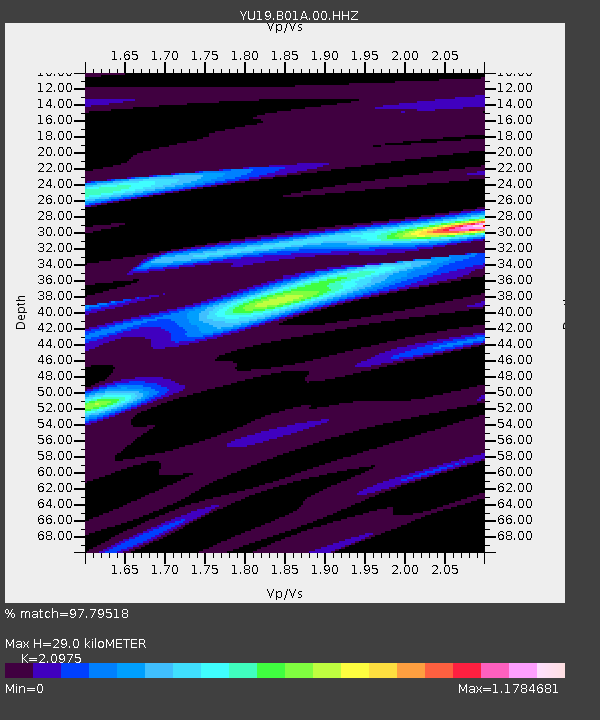
| Estimated Moho Depth: |
29.0 km |
| Estimated Crust Vp/Vs: |
2.10 |
| Assumed Crust Vp: |
6.476 km/s |
| Estimated Crust Vs: |
3.087 km/s |
| Estimated Crust Poisson's Ratio: |
0.35 |
|
| Radial Match: |
97.79518 % |
| Radial Bump: |
298 |
| Transverse Match: |
93.71782 % |
| Transverse Bump: |
400 |
| SOD ConfigId: |
30536071 |
| Insert Time: |
2023-07-30 07:39:18.631 +0000 |
| GWidth: |
2.5 |
| Max Bumps: |
400 |
| Tol: |
0.001 |
|

Signal To Noise
| Channel | StoN | STA | LTA |
| YU:B01A:00:HHZ:20230716T06:57:11.315002Z | 41.73898 | 4.517284E-6 | 1.08227E-7 |
| YU:B01A:00:HHN:20230716T06:57:11.315002Z | 22.626247 | 2.2782951E-6 | 1.0069257E-7 |
| YU:B01A:00:HHE:20230716T06:57:11.315002Z | 12.538596 | 1.0855341E-6 | 8.657541E-8 |
| Arrivals |
| Ps | 5.1 SECOND |
| PpPs | 13 SECOND |
| PsPs/PpSs | 18 SECOND |


