You are here: Home > Network List > TA - USArray Transportable Network (new EarthScope stations) Stations List
> Station Q34A Chapman, KS, USA > Earthquake Result Viewer
Q34A Chapman, KS, USA - Earthquake Result Viewer

| Earthquake location: |
Costa Rica |
| Earthquake latitude/longitude: |
9.3/-84.2 |
| Earthquake time(UTC): |
2010/06/01 (152) 03:26:15 GMT |
| Earthquake Depth: |
18 km |
| Earthquake Magnitude: |
5.7 MB, 5.6 MS, 6.0 MW, 5.9 MW |
| Earthquake Catalog/Contributor: |
WHDF/NEIC |
|
| Network: |
TA USArray Transportable Network (new EarthScope stations) |
| Station: |
Q34A Chapman, KS, USA |
| Lat/Lon: |
38.92 N/96.94 W |
| Elevation: |
378 m |
|
| Distance: |
31.6 deg |
| Az: |
340.842 deg |
| Baz: |
155.468 deg |
| Ray Param: |
0.078992315 |
| Estimated Moho Depth: |
43.75 km |
| Estimated Crust Vp/Vs: |
1.78 |
| Assumed Crust Vp: |
6.483 km/s |
| Estimated Crust Vs: |
3.637 km/s |
| Estimated Crust Poisson's Ratio: |
0.27 |
|
| Radial Match: |
82.95274 % |
| Radial Bump: |
333 |
| Transverse Match: |
52.50145 % |
| Transverse Bump: |
400 |
| SOD ConfigId: |
317696 |
| Insert Time: |
2010-09-19 07:16:21.763 +0000 |
| GWidth: |
2.5 |
| Max Bumps: |
400 |
| Tol: |
0.001 |
|
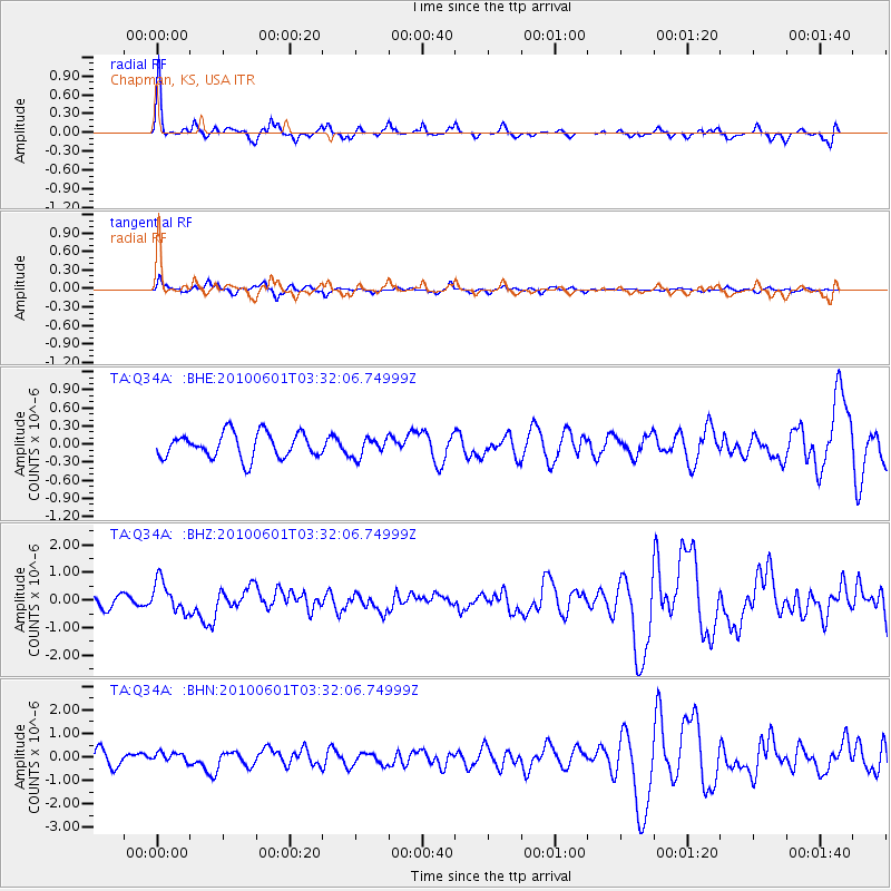
Signal To Noise
| Channel | StoN | STA | LTA |
| TA:Q34A: :BHZ:20100601T03:32:06.74999Z | 3.137682 | 5.655751E-7 | 1.8025251E-7 |
| TA:Q34A: :BHN:20100601T03:32:06.74999Z | 0.4850436 | 2.0868028E-7 | 4.3022996E-7 |
| TA:Q34A: :BHE:20100601T03:32:06.74999Z | 0.7667224 | 1.580421E-7 | 2.0612688E-7 |
| Arrivals |
| Ps | 5.7 SECOND |
| PpPs | 17 SECOND |
| PsPs/PpSs | 23 SECOND |


