You are here: Home > Network List > UW - Pacific Northwest Regional Seismic Network Stations List
> Station PASS Maple Falls, WA, USA > Earthquake Result Viewer
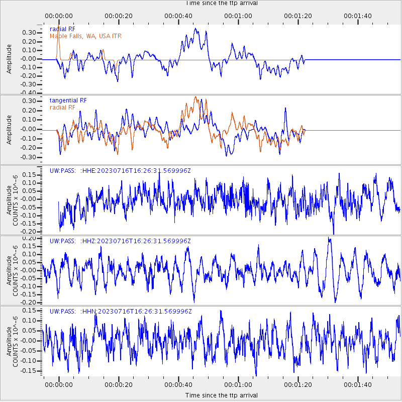
PASS Maple Falls, WA, USA - Earthquake Result Viewer
*The percent match for this event was below the threshold and hence no stack was calculated.
| Earthquake location: |
New Britain Region, P.N.G. |
| Earthquake latitude/longitude: |
-5.8/148.3 |
| Earthquake time(UTC): |
2023/07/16 (197) 16:14:00 GMT |
| Earthquake Depth: |
137 km |
| Earthquake Magnitude: |
5.1 Mww |
| Earthquake Catalog/Contributor: |
NEIC PDE/us |
|
| Network: |
UW Pacific Northwest Regional Seismic Network |
| Station: |
PASS Maple Falls, WA, USA |
| Lat/Lon: |
49.00 N/122.09 W |
| Elevation: |
174 m |
|
| Distance: |
94.1 deg |
| Az: |
41.318 deg |
| Baz: |
265.955 deg |
| Ray Param: |
$rayparam |
*The percent match for this event was below the threshold and hence was not used in the summary stack. |
|
| Radial Match: |
51.878628 % |
| Radial Bump: |
400 |
| Transverse Match: |
52.018955 % |
| Transverse Bump: |
400 |
| SOD ConfigId: |
30536071 |
| Insert Time: |
2023-07-30 16:44:06.372 +0000 |
| GWidth: |
2.5 |
| Max Bumps: |
400 |
| Tol: |
0.001 |
|
Signal To Noise
| Channel | StoN | STA | LTA |
| UW:PASS: :HHZ:20230716T16:26:31.569996Z | 1.5409106 | 7.430316E-8 | 4.8220294E-8 |
| UW:PASS: :HHN:20230716T16:26:31.569996Z | 1.1074454 | 6.345385E-8 | 5.7297495E-8 |
| UW:PASS: :HHE:20230716T16:26:31.569996Z | 1.2611753 | 7.651368E-8 | 6.0668555E-8 |
| Arrivals |
| Ps | |
| PpPs | |
| PsPs/PpSs | |


