You are here: Home > Network List > AG - Arkansas Seismic Network Stations List
> Station WHAR Woolly Hollow State Park,AR > Earthquake Result Viewer
WHAR Woolly Hollow State Park,AR - Earthquake Result Viewer
| Earthquake location: |
Southern Argentina |
| Earthquake latitude/longitude: |
-38.2/-70.4 |
| Earthquake time(UTC): |
2023/07/17 (198) 03:05:10 GMT |
| Earthquake Depth: |
171 km |
| Earthquake Magnitude: |
6.6 mww |
| Earthquake Catalog/Contributor: |
NEIC PDE/us |
|
| Network: |
AG Arkansas Seismic Network |
| Station: |
WHAR Woolly Hollow State Park,AR |
| Lat/Lon: |
35.29 N/92.29 W |
| Elevation: |
184 m |
|
| Distance: |
75.9 deg |
| Az: |
341.648 deg |
| Baz: |
162.346 deg |
| Ray Param: |
0.0509388 |
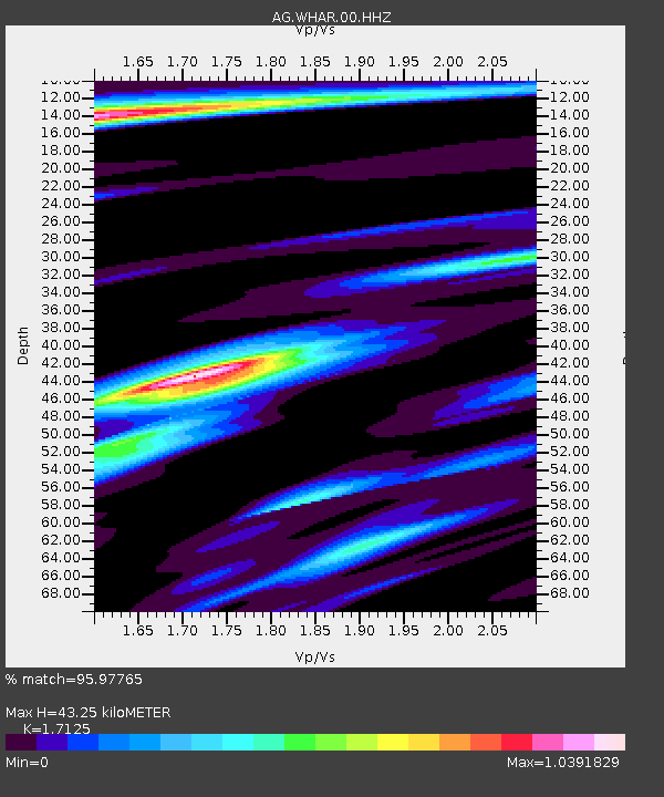
| Estimated Moho Depth: |
43.25 km |
| Estimated Crust Vp/Vs: |
1.71 |
| Assumed Crust Vp: |
6.498 km/s |
| Estimated Crust Vs: |
3.794 km/s |
| Estimated Crust Poisson's Ratio: |
0.24 |
|
| Radial Match: |
95.97765 % |
| Radial Bump: |
289 |
| Transverse Match: |
90.50311 % |
| Transverse Bump: |
400 |
| SOD ConfigId: |
30536071 |
| Insert Time: |
2023-07-31 03:08:59.137 +0000 |
| GWidth: |
2.5 |
| Max Bumps: |
400 |
| Tol: |
0.001 |
|

Signal To Noise
| Channel | StoN | STA | LTA |
| AG:WHAR:00:HHZ:20230717T03:16:07.45002Z | 60.868534 | 4.5495567E-6 | 7.474398E-8 |
| AG:WHAR:00:HHN:20230717T03:16:07.45002Z | 51.876244 | 2.0889859E-6 | 4.026864E-8 |
| AG:WHAR:00:HHE:20230717T03:16:07.45002Z | 10.409401 | 7.0820664E-7 | 6.80353E-8 |
| Arrivals |
| Ps | 4.9 SECOND |
| PpPs | 17 SECOND |
| PsPs/PpSs | 22 SECOND |


