You are here: Home > Network List > AZ - ANZA Regional Network Stations List
> Station SMER AZ.SMER > Earthquake Result Viewer
SMER AZ.SMER - Earthquake Result Viewer
| Earthquake location: |
Southern Argentina |
| Earthquake latitude/longitude: |
-38.2/-70.4 |
| Earthquake time(UTC): |
2023/07/17 (198) 03:05:10 GMT |
| Earthquake Depth: |
171 km |
| Earthquake Magnitude: |
6.6 mww |
| Earthquake Catalog/Contributor: |
NEIC PDE/us |
|
| Network: |
AZ ANZA Regional Network |
| Station: |
SMER AZ.SMER |
| Lat/Lon: |
33.46 N/117.17 W |
| Elevation: |
355 m |
|
| Distance: |
83.5 deg |
| Az: |
322.17 deg |
| Baz: |
144.684 deg |
| Ray Param: |
0.045735527 |
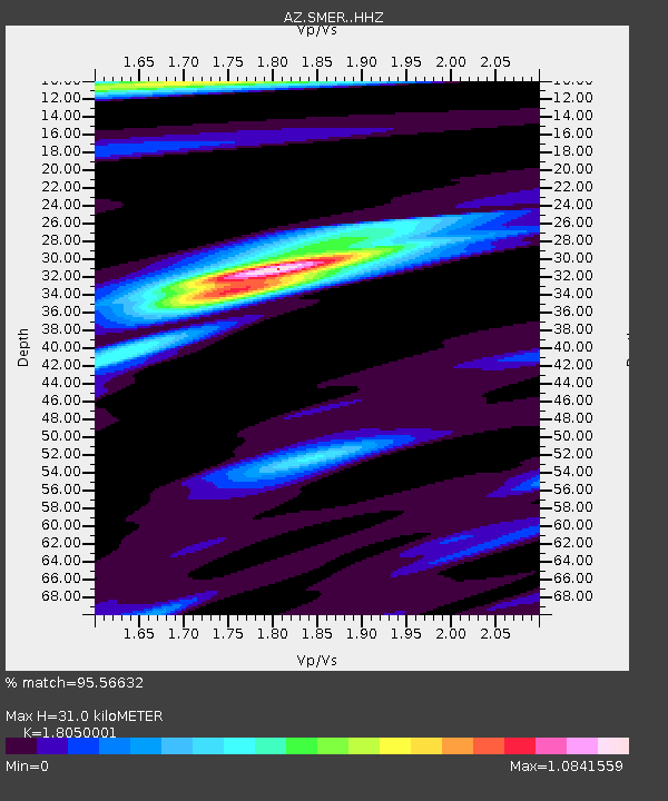
| Estimated Moho Depth: |
31.0 km |
| Estimated Crust Vp/Vs: |
1.81 |
| Assumed Crust Vp: |
6.264 km/s |
| Estimated Crust Vs: |
3.47 km/s |
| Estimated Crust Poisson's Ratio: |
0.28 |
|
| Radial Match: |
95.56632 % |
| Radial Bump: |
330 |
| Transverse Match: |
83.34322 % |
| Transverse Bump: |
400 |
| SOD ConfigId: |
30536071 |
| Insert Time: |
2023-07-31 03:09:36.584 +0000 |
| GWidth: |
2.5 |
| Max Bumps: |
400 |
| Tol: |
0.001 |
|
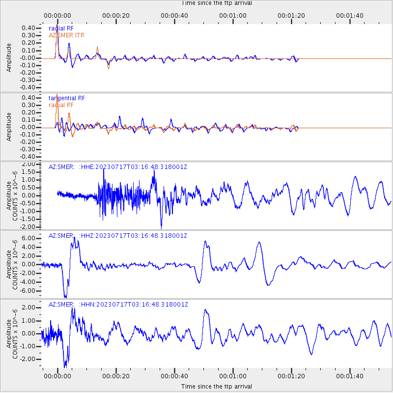
Signal To Noise
| Channel | StoN | STA | LTA |
| AZ:SMER: :HHZ:20230717T03:16:48.318001Z | 14.577767 | 3.7806183E-6 | 2.5934136E-7 |
| AZ:SMER: :HHN:20230717T03:16:48.318001Z | 4.4783993 | 1.2902611E-6 | 2.8810766E-7 |
| AZ:SMER: :HHE:20230717T03:16:48.318001Z | 1.6278586 | 5.848833E-7 | 3.5929614E-7 |
| Arrivals |
| Ps | 4.1 SECOND |
| PpPs | 14 SECOND |
| PsPs/PpSs | 18 SECOND |


