You are here: Home > Network List > UW - Pacific Northwest Regional Seismic Network Stations List
> Station UMAT Pilot Rock, OR, USA > Earthquake Result Viewer
UMAT Pilot Rock, OR, USA - Earthquake Result Viewer
*The percent match for this event was below the threshold and hence no stack was calculated.
| Earthquake location: |
Costa Rica |
| Earthquake latitude/longitude: |
9.3/-84.2 |
| Earthquake time(UTC): |
2010/06/01 (152) 03:26:15 GMT |
| Earthquake Depth: |
18 km |
| Earthquake Magnitude: |
5.7 MB, 5.6 MS, 6.0 MW, 5.9 MW |
| Earthquake Catalog/Contributor: |
WHDF/NEIC |
|
| Network: |
UW Pacific Northwest Regional Seismic Network |
| Station: |
UMAT Pilot Rock, OR, USA |
| Lat/Lon: |
45.29 N/118.96 W |
| Elevation: |
1318 m |
|
| Distance: |
46.6 deg |
| Az: |
326.4 deg |
| Baz: |
129.31 deg |
| Ray Param: |
$rayparam |
*The percent match for this event was below the threshold and hence was not used in the summary stack. |
|
| Radial Match: |
74.37271 % |
| Radial Bump: |
342 |
| Transverse Match: |
53.745773 % |
| Transverse Bump: |
368 |
| SOD ConfigId: |
317696 |
| Insert Time: |
2010-09-19 07:20:52.226 +0000 |
| GWidth: |
2.5 |
| Max Bumps: |
400 |
| Tol: |
0.001 |
|
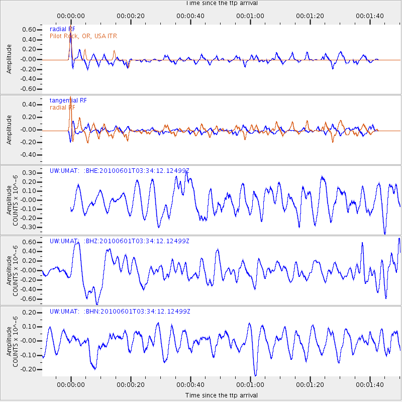
Signal To Noise
| Channel | StoN | STA | LTA |
| UW:UMAT: :BHZ:20100601T03:34:12.12499Z | 6.2844167 | 3.8806903E-7 | 6.1751E-8 |
| UW:UMAT: :BHN:20100601T03:34:12.12499Z | 0.33088133 | 1.8727329E-8 | 5.6598328E-8 |
| UW:UMAT: :BHE:20100601T03:34:12.12499Z | 1.6215721 | 1.6253652E-7 | 1.0023392E-7 |
| Arrivals |
| Ps | |
| PpPs | |
| PsPs/PpSs | |


