You are here: Home > Network List > GM - US Geological Survey Networks Stations List
> Station IWM01 Jericho 2M Well Monitoring Station > Earthquake Result Viewer
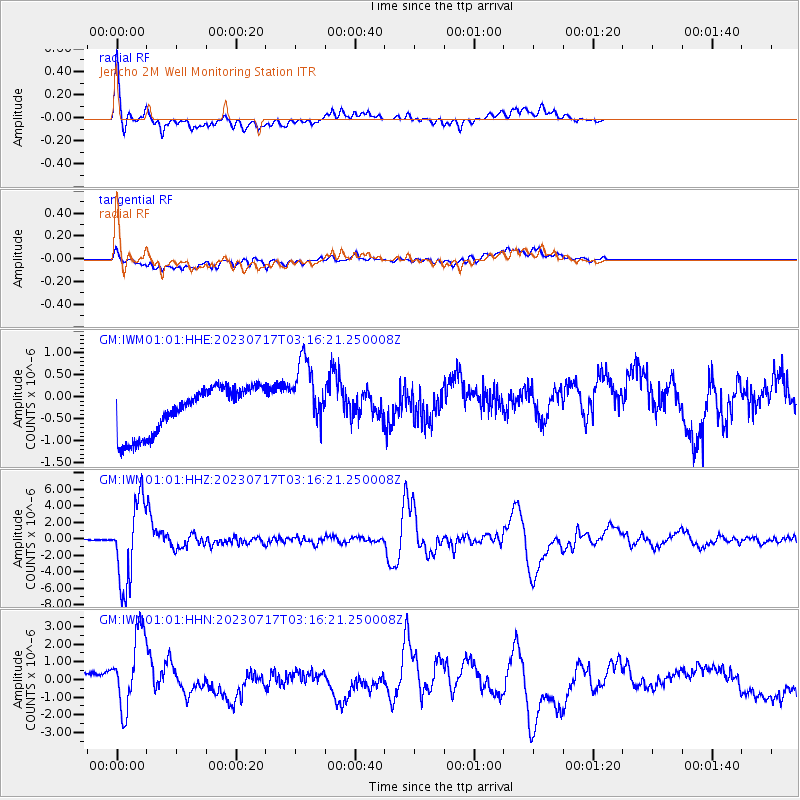
IWM01 Jericho 2M Well Monitoring Station - Earthquake Result Viewer
*The percent match for this event was below the threshold and hence no stack was calculated.
| Earthquake location: |
Southern Argentina |
| Earthquake latitude/longitude: |
-38.2/-70.4 |
| Earthquake time(UTC): |
2023/07/17 (198) 03:05:10 GMT |
| Earthquake Depth: |
171 km |
| Earthquake Magnitude: |
6.6 mww |
| Earthquake Catalog/Contributor: |
NEIC PDE/us |
|
| Network: |
GM US Geological Survey Networks |
| Station: |
IWM01 Jericho 2M Well Monitoring Station |
| Lat/Lon: |
36.73 N/96.53 W |
| Elevation: |
328 m |
|
| Distance: |
78.4 deg |
| Az: |
338.801 deg |
| Baz: |
159.227 deg |
| Ray Param: |
$rayparam |
*The percent match for this event was below the threshold and hence was not used in the summary stack. |
|
| Radial Match: |
78.58218 % |
| Radial Bump: |
400 |
| Transverse Match: |
44.394146 % |
| Transverse Bump: |
400 |
| SOD ConfigId: |
30536071 |
| Insert Time: |
2023-07-31 03:20:44.473 +0000 |
| GWidth: |
2.5 |
| Max Bumps: |
400 |
| Tol: |
0.001 |
|
Signal To Noise
| Channel | StoN | STA | LTA |
| GM:IWM01:01:HHZ:20230717T03:16:21.250008Z | 69.07947 | 4.951007E-6 | 7.167119E-8 |
| GM:IWM01:01:HHN:20230717T03:16:21.250008Z | 2.2127616 | 2.3472085E-6 | 1.0607597E-6 |
| GM:IWM01:01:HHE:20230717T03:16:21.250008Z | 1.5293679 | 8.087186E-7 | 5.287927E-7 |
| Arrivals |
| Ps | |
| PpPs | |
| PsPs/PpSs | |


