You are here: Home > Network List > US - United States National Seismic Network Stations List
> Station EGMT Eagleton, Montana, USA > Earthquake Result Viewer
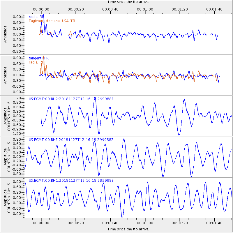
EGMT Eagleton, Montana, USA - Earthquake Result Viewer
*The percent match for this event was below the threshold and hence no stack was calculated.
| Earthquake location: |
North Of Ascension Island |
| Earthquake latitude/longitude: |
-1.0/-13.7 |
| Earthquake time(UTC): |
2018/11/27 (331) 12:03:28 GMT |
| Earthquake Depth: |
10 km |
| Earthquake Magnitude: |
5.8 Mww |
| Earthquake Catalog/Contributor: |
NEIC PDE/us |
|
| Network: |
US United States National Seismic Network |
| Station: |
EGMT Eagleton, Montana, USA |
| Lat/Lon: |
48.02 N/109.75 W |
| Elevation: |
1055 m |
|
| Distance: |
94.8 deg |
| Az: |
317.941 deg |
| Baz: |
86.164 deg |
| Ray Param: |
$rayparam |
*The percent match for this event was below the threshold and hence was not used in the summary stack. |
|
| Radial Match: |
60.533035 % |
| Radial Bump: |
400 |
| Transverse Match: |
57.823624 % |
| Transverse Bump: |
400 |
| SOD ConfigId: |
3165032 |
| Insert Time: |
2018-12-11 12:10:47.791 +0000 |
| GWidth: |
2.5 |
| Max Bumps: |
400 |
| Tol: |
0.001 |
|
Signal To Noise
| Channel | StoN | STA | LTA |
| US:EGMT:00:BHZ:20181127T12:16:18.299988Z | 0.98735595 | 2.2559098E-7 | 2.2847989E-7 |
| US:EGMT:00:BH1:20181127T12:16:18.299988Z | 0.86669 | 4.075869E-7 | 4.7027993E-7 |
| US:EGMT:00:BH2:20181127T12:16:18.299988Z | 1.7218896 | 8.1268956E-7 | 4.719754E-7 |
| Arrivals |
| Ps | |
| PpPs | |
| PsPs/PpSs | |


