You are here: Home > Network List > IW - Intermountain West Stations List
> Station IMW Indian Meadow, Wyoming, USA > Earthquake Result Viewer
IMW Indian Meadow, Wyoming, USA - Earthquake Result Viewer
| Earthquake location: |
Southern Argentina |
| Earthquake latitude/longitude: |
-38.2/-70.4 |
| Earthquake time(UTC): |
2023/07/17 (198) 03:05:10 GMT |
| Earthquake Depth: |
171 km |
| Earthquake Magnitude: |
6.6 mww |
| Earthquake Catalog/Contributor: |
NEIC PDE/us |
|
| Network: |
IW Intermountain West |
| Station: |
IMW Indian Meadow, Wyoming, USA |
| Lat/Lon: |
43.90 N/110.94 W |
| Elevation: |
2646 m |
|
| Distance: |
89.6 deg |
| Az: |
331.957 deg |
| Baz: |
149.173 deg |
| Ray Param: |
0.04172234 |
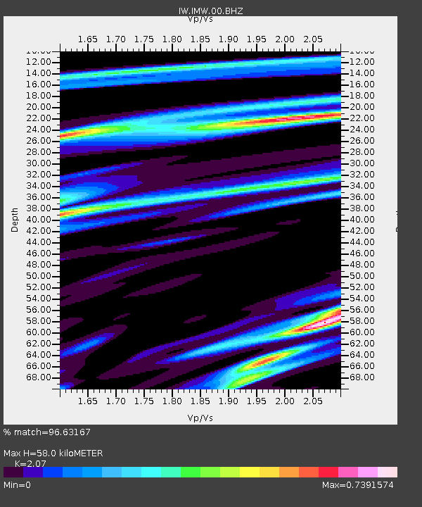
| Estimated Moho Depth: |
58.0 km |
| Estimated Crust Vp/Vs: |
2.07 |
| Assumed Crust Vp: |
6.207 km/s |
| Estimated Crust Vs: |
2.998 km/s |
| Estimated Crust Poisson's Ratio: |
0.35 |
|
| Radial Match: |
96.63167 % |
| Radial Bump: |
293 |
| Transverse Match: |
91.32391 % |
| Transverse Bump: |
400 |
| SOD ConfigId: |
30536071 |
| Insert Time: |
2023-07-31 03:23:06.890 +0000 |
| GWidth: |
2.5 |
| Max Bumps: |
400 |
| Tol: |
0.001 |
|
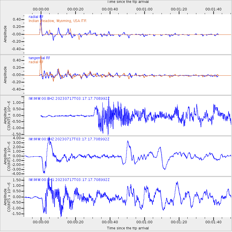
Signal To Noise
| Channel | StoN | STA | LTA |
| IW:IMW:00:BHZ:20230717T03:17:17.708992Z | 36.75886 | 2.3559517E-6 | 6.409208E-8 |
| IW:IMW:00:BH1:20230717T03:17:17.708992Z | 18.356325 | 8.067371E-7 | 4.3948724E-8 |
| IW:IMW:00:BH2:20230717T03:17:17.708992Z | 14.01608 | 5.045998E-7 | 3.6001495E-8 |
| Arrivals |
| Ps | 10 SECOND |
| PpPs | 28 SECOND |
| PsPs/PpSs | 38 SECOND |


