You are here: Home > Network List > IW - Intermountain West Stations List
> Station TPAW Teton Pass, Wyoming, USA > Earthquake Result Viewer
TPAW Teton Pass, Wyoming, USA - Earthquake Result Viewer
| Earthquake location: |
Southern Argentina |
| Earthquake latitude/longitude: |
-38.2/-70.4 |
| Earthquake time(UTC): |
2023/07/17 (198) 03:05:10 GMT |
| Earthquake Depth: |
171 km |
| Earthquake Magnitude: |
6.6 mww |
| Earthquake Catalog/Contributor: |
NEIC PDE/us |
|
| Network: |
IW Intermountain West |
| Station: |
TPAW Teton Pass, Wyoming, USA |
| Lat/Lon: |
43.49 N/110.95 W |
| Elevation: |
2512 m |
|
| Distance: |
89.2 deg |
| Az: |
331.741 deg |
| Baz: |
149.163 deg |
| Ray Param: |
0.041732144 |
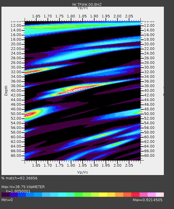
| Estimated Moho Depth: |
39.75 km |
| Estimated Crust Vp/Vs: |
1.81 |
| Assumed Crust Vp: |
6.207 km/s |
| Estimated Crust Vs: |
3.439 km/s |
| Estimated Crust Poisson's Ratio: |
0.28 |
|
| Radial Match: |
92.36656 % |
| Radial Bump: |
400 |
| Transverse Match: |
79.05582 % |
| Transverse Bump: |
400 |
| SOD ConfigId: |
30536071 |
| Insert Time: |
2023-07-31 03:23:20.156 +0000 |
| GWidth: |
2.5 |
| Max Bumps: |
400 |
| Tol: |
0.001 |
|

Signal To Noise
| Channel | StoN | STA | LTA |
| IW:TPAW:00:BHZ:20230717T03:17:16.138985Z | 42.22854 | 2.5919385E-6 | 6.137884E-8 |
| IW:TPAW:00:BH1:20230717T03:17:16.138985Z | 15.022011 | 7.799262E-7 | 5.1918896E-8 |
| IW:TPAW:00:BH2:20230717T03:17:16.138985Z | 10.678051 | 5.915025E-7 | 5.539424E-8 |
| Arrivals |
| Ps | 5.3 SECOND |
| PpPs | 18 SECOND |
| PsPs/PpSs | 23 SECOND |


