You are here: Home > Network List > G - GEOSCOPE Stations List
> Station KIP Kipapa, Hawai, U.S.A. (Pacific Ocean) > Earthquake Result Viewer
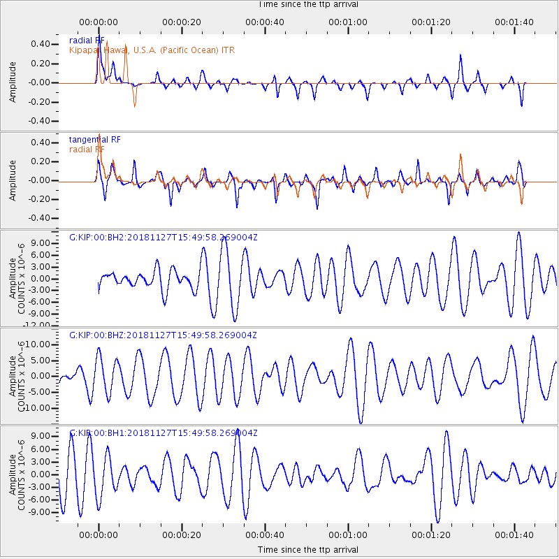
KIP Kipapa, Hawai, U.S.A. (Pacific Ocean) - Earthquake Result Viewer
*The percent match for this event was below the threshold and hence no stack was calculated.
| Earthquake location: |
Southeast Of Loyalty Islands |
| Earthquake latitude/longitude: |
-21.3/171.3 |
| Earthquake time(UTC): |
2018/11/27 (331) 15:41:20 GMT |
| Earthquake Depth: |
10 km |
| Earthquake Magnitude: |
5.8 Mww |
| Earthquake Catalog/Contributor: |
NEIC PDE/us |
|
| Network: |
G GEOSCOPE |
| Station: |
KIP Kipapa, Hawai, U.S.A. (Pacific Ocean) |
| Lat/Lon: |
21.42 N/158.01 W |
| Elevation: |
70 m |
|
| Distance: |
52.0 deg |
| Az: |
37.072 deg |
| Baz: |
217.096 deg |
| Ray Param: |
$rayparam |
*The percent match for this event was below the threshold and hence was not used in the summary stack. |
|
| Radial Match: |
54.4161 % |
| Radial Bump: |
277 |
| Transverse Match: |
64.22588 % |
| Transverse Bump: |
364 |
| SOD ConfigId: |
3165032 |
| Insert Time: |
2018-12-11 15:44:34.557 +0000 |
| GWidth: |
2.5 |
| Max Bumps: |
400 |
| Tol: |
0.001 |
|
Signal To Noise
| Channel | StoN | STA | LTA |
| G:KIP:00:BHZ:20181127T15:49:58.269004Z | 1.435379 | 5.633481E-6 | 3.924734E-6 |
| G:KIP:00:BH1:20181127T15:49:58.269004Z | 0.7209946 | 4.8016586E-6 | 6.659771E-6 |
| G:KIP:00:BH2:20181127T15:49:58.269004Z | 3.2780185 | 7.4907907E-6 | 2.2851582E-6 |
| Arrivals |
| Ps | |
| PpPs | |
| PsPs/PpSs | |


