You are here: Home > Network List > N4 - Central and EAstern US Network Stations List
> Station SFIN Lafayette, IN, USA > Earthquake Result Viewer
SFIN Lafayette, IN, USA - Earthquake Result Viewer
| Earthquake location: |
Southern Argentina |
| Earthquake latitude/longitude: |
-38.2/-70.4 |
| Earthquake time(UTC): |
2023/07/17 (198) 03:05:10 GMT |
| Earthquake Depth: |
171 km |
| Earthquake Magnitude: |
6.6 mww |
| Earthquake Catalog/Contributor: |
NEIC PDE/us |
|
| Network: |
N4 Central and EAstern US Network |
| Station: |
SFIN Lafayette, IN, USA |
| Lat/Lon: |
40.38 N/87.10 W |
| Elevation: |
165 m |
|
| Distance: |
79.7 deg |
| Az: |
347.089 deg |
| Baz: |
166.675 deg |
| Ray Param: |
0.048382156 |
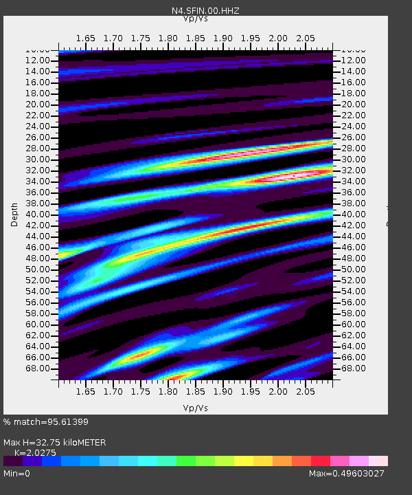
| Estimated Moho Depth: |
32.75 km |
| Estimated Crust Vp/Vs: |
2.03 |
| Assumed Crust Vp: |
6.498 km/s |
| Estimated Crust Vs: |
3.205 km/s |
| Estimated Crust Poisson's Ratio: |
0.34 |
|
| Radial Match: |
95.61399 % |
| Radial Bump: |
292 |
| Transverse Match: |
90.48659 % |
| Transverse Bump: |
400 |
| SOD ConfigId: |
30536071 |
| Insert Time: |
2023-07-31 03:28:03.030 +0000 |
| GWidth: |
2.5 |
| Max Bumps: |
400 |
| Tol: |
0.001 |
|

Signal To Noise
| Channel | StoN | STA | LTA |
| N4:SFIN:00:HHZ:20230717T03:16:28.349983Z | 44.365788 | 3.6778542E-6 | 8.289843E-8 |
| N4:SFIN:00:HH1:20230717T03:16:28.349983Z | 25.245485 | 1.4782644E-6 | 5.8555592E-8 |
| N4:SFIN:00:HH2:20230717T03:16:28.349983Z | 5.1892266 | 2.8450208E-7 | 5.4825527E-8 |
| Arrivals |
| Ps | 5.3 SECOND |
| PpPs | 15 SECOND |
| PsPs/PpSs | 20 SECOND |


