You are here: Home > Network List > N4 - Central and EAstern US Network Stations List
> Station Y57A Sumter, SC, USA > Earthquake Result Viewer
Y57A Sumter, SC, USA - Earthquake Result Viewer
| Earthquake location: |
Southern Argentina |
| Earthquake latitude/longitude: |
-38.2/-70.4 |
| Earthquake time(UTC): |
2023/07/17 (198) 03:05:10 GMT |
| Earthquake Depth: |
171 km |
| Earthquake Magnitude: |
6.6 mww |
| Earthquake Catalog/Contributor: |
NEIC PDE/us |
|
| Network: |
N4 Central and EAstern US Network |
| Station: |
Y57A Sumter, SC, USA |
| Lat/Lon: |
34.02 N/80.39 W |
| Elevation: |
56 m |
|
| Distance: |
72.4 deg |
| Az: |
351.283 deg |
| Baz: |
171.734 deg |
| Ray Param: |
0.053213254 |
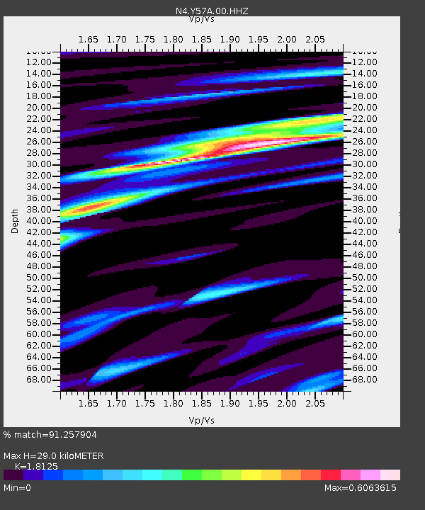
| Estimated Moho Depth: |
29.0 km |
| Estimated Crust Vp/Vs: |
1.81 |
| Assumed Crust Vp: |
6.419 km/s |
| Estimated Crust Vs: |
3.542 km/s |
| Estimated Crust Poisson's Ratio: |
0.28 |
|
| Radial Match: |
91.257904 % |
| Radial Bump: |
400 |
| Transverse Match: |
70.91368 % |
| Transverse Bump: |
400 |
| SOD ConfigId: |
30536071 |
| Insert Time: |
2023-07-31 03:28:50.377 +0000 |
| GWidth: |
2.5 |
| Max Bumps: |
400 |
| Tol: |
0.001 |
|

Signal To Noise
| Channel | StoN | STA | LTA |
| N4:Y57A:00:HHZ:20230717T03:15:47.599983Z | 38.835075 | 3.980667E-6 | 1.0250184E-7 |
| N4:Y57A:00:HH1:20230717T03:15:47.599983Z | 12.955368 | 1.8538651E-6 | 1.4309629E-7 |
| N4:Y57A:00:HH2:20230717T03:15:47.599983Z | 4.111944 | 5.9675966E-7 | 1.4512835E-7 |
| Arrivals |
| Ps | 3.8 SECOND |
| PpPs | 12 SECOND |
| PsPs/PpSs | 16 SECOND |


