You are here: Home > Network List > NM - Cooperative New Madrid Seismic Network Stations List
> Station LPAR Lepanto,AR > Earthquake Result Viewer
LPAR Lepanto,AR - Earthquake Result Viewer
| Earthquake location: |
Southern Argentina |
| Earthquake latitude/longitude: |
-38.2/-70.4 |
| Earthquake time(UTC): |
2023/07/17 (198) 03:05:10 GMT |
| Earthquake Depth: |
171 km |
| Earthquake Magnitude: |
6.6 mww |
| Earthquake Catalog/Contributor: |
NEIC PDE/us |
|
| Network: |
NM Cooperative New Madrid Seismic Network |
| Station: |
LPAR Lepanto,AR |
| Lat/Lon: |
35.60 N/90.30 W |
| Elevation: |
67 m |
|
| Distance: |
75.7 deg |
| Az: |
343.345 deg |
| Baz: |
163.911 deg |
| Ray Param: |
0.051054135 |
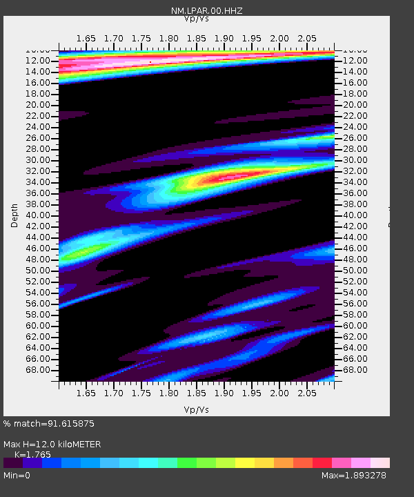
| Estimated Moho Depth: |
12.0 km |
| Estimated Crust Vp/Vs: |
1.76 |
| Assumed Crust Vp: |
6.273 km/s |
| Estimated Crust Vs: |
3.554 km/s |
| Estimated Crust Poisson's Ratio: |
0.26 |
|
| Radial Match: |
91.615875 % |
| Radial Bump: |
400 |
| Transverse Match: |
79.78864 % |
| Transverse Bump: |
400 |
| SOD ConfigId: |
30536071 |
| Insert Time: |
2023-07-31 03:29:53.552 +0000 |
| GWidth: |
2.5 |
| Max Bumps: |
400 |
| Tol: |
0.001 |
|

Signal To Noise
| Channel | StoN | STA | LTA |
| NM:LPAR:00:HHZ:20230717T03:16:06.469979Z | 41.064926 | 4.912438E-6 | 1.1962612E-7 |
| NM:LPAR:00:HHN:20230717T03:16:06.469979Z | 11.89885 | 3.0632464E-6 | 2.5744055E-7 |
| NM:LPAR:00:HHE:20230717T03:16:06.469979Z | 3.776459 | 1.1189308E-6 | 2.96291E-7 |
| Arrivals |
| Ps | 1.5 SECOND |
| PpPs | 5.1 SECOND |
| PsPs/PpSs | 6.6 SECOND |


