You are here: Home > Network List > NW - Northwestern University Seismic Network Stations List
> Station L44A Ryerson Woods, Lake Cnty Forest Preserve, IL, USA > Earthquake Result Viewer
L44A Ryerson Woods, Lake Cnty Forest Preserve, IL, USA - Earthquake Result Viewer
| Earthquake location: |
Southern Argentina |
| Earthquake latitude/longitude: |
-38.2/-70.4 |
| Earthquake time(UTC): |
2023/07/17 (198) 03:05:10 GMT |
| Earthquake Depth: |
171 km |
| Earthquake Magnitude: |
6.6 mww |
| Earthquake Catalog/Contributor: |
NEIC PDE/us |
|
| Network: |
NW Northwestern University Seismic Network |
| Station: |
L44A Ryerson Woods, Lake Cnty Forest Preserve, IL, USA |
| Lat/Lon: |
42.18 N/87.91 W |
| Elevation: |
202 m |
|
| Distance: |
81.6 deg |
| Az: |
346.912 deg |
| Baz: |
166.111 deg |
| Ray Param: |
0.04708139 |
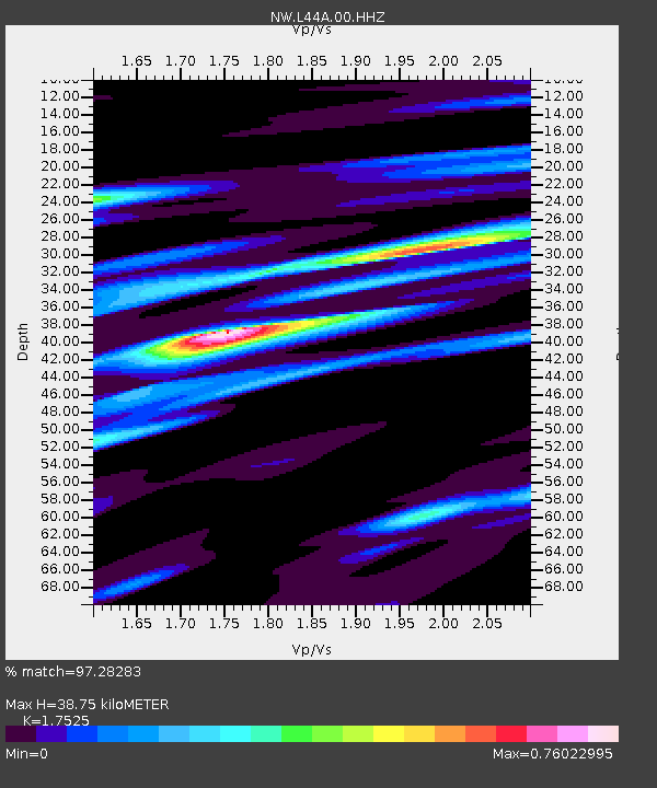
| Estimated Moho Depth: |
38.75 km |
| Estimated Crust Vp/Vs: |
1.75 |
| Assumed Crust Vp: |
6.483 km/s |
| Estimated Crust Vs: |
3.699 km/s |
| Estimated Crust Poisson's Ratio: |
0.26 |
|
| Radial Match: |
97.28283 % |
| Radial Bump: |
389 |
| Transverse Match: |
88.34343 % |
| Transverse Bump: |
400 |
| SOD ConfigId: |
30536071 |
| Insert Time: |
2023-07-31 03:31:59.997 +0000 |
| GWidth: |
2.5 |
| Max Bumps: |
400 |
| Tol: |
0.001 |
|

Signal To Noise
| Channel | StoN | STA | LTA |
| NW:L44A:00:HHZ:20230717T03:16:38.359017Z | 44.88925 | 4.557009E-6 | 1.01516704E-7 |
| NW:L44A:00:HH1:20230717T03:16:38.359017Z | 13.9184065 | 1.792678E-6 | 1.2879909E-7 |
| NW:L44A:00:HH2:20230717T03:16:38.359017Z | 6.5222464 | 6.8002544E-7 | 1.04262455E-7 |
| Arrivals |
| Ps | 4.6 SECOND |
| PpPs | 16 SECOND |
| PsPs/PpSs | 21 SECOND |


