You are here: Home > Network List > O2 - Oklahoma Consolidated Temporary Seismic Networks Stations List
> Station FREE Freedom, Oklahoma, USA > Earthquake Result Viewer
FREE Freedom, Oklahoma, USA - Earthquake Result Viewer
| Earthquake location: |
Southern Argentina |
| Earthquake latitude/longitude: |
-38.2/-70.4 |
| Earthquake time(UTC): |
2023/07/17 (198) 03:05:10 GMT |
| Earthquake Depth: |
171 km |
| Earthquake Magnitude: |
6.6 mww |
| Earthquake Catalog/Contributor: |
NEIC PDE/us |
|
| Network: |
O2 Oklahoma Consolidated Temporary Seismic Networks |
| Station: |
FREE Freedom, Oklahoma, USA |
| Lat/Lon: |
36.93 N/99.27 W |
| Elevation: |
563 m |
|
| Distance: |
79.4 deg |
| Az: |
336.798 deg |
| Baz: |
157.206 deg |
| Ray Param: |
0.048592057 |
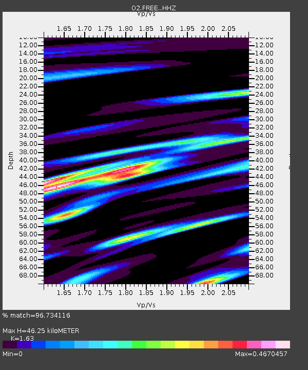
| Estimated Moho Depth: |
46.25 km |
| Estimated Crust Vp/Vs: |
1.63 |
| Assumed Crust Vp: |
6.426 km/s |
| Estimated Crust Vs: |
3.942 km/s |
| Estimated Crust Poisson's Ratio: |
0.20 |
|
| Radial Match: |
96.734116 % |
| Radial Bump: |
282 |
| Transverse Match: |
89.741394 % |
| Transverse Bump: |
400 |
| SOD ConfigId: |
30536071 |
| Insert Time: |
2023-07-31 03:32:33.508 +0000 |
| GWidth: |
2.5 |
| Max Bumps: |
400 |
| Tol: |
0.001 |
|

Signal To Noise
| Channel | StoN | STA | LTA |
| O2:FREE: :HHZ:20230717T03:16:26.695015Z | 68.0028 | 4.5232687E-6 | 6.6515916E-8 |
| O2:FREE: :HHN:20230717T03:16:26.695015Z | 16.50656 | 1.5556702E-6 | 9.424558E-8 |
| O2:FREE: :HHE:20230717T03:16:26.695015Z | 9.17211 | 1.3091812E-6 | 1.4273502E-7 |
| Arrivals |
| Ps | 4.7 SECOND |
| PpPs | 18 SECOND |
| PsPs/PpSs | 23 SECOND |


